Xoixar elevation
Xoixar (Tibet), China elevation is 4452 meters and Xoixar elevation in feet is 14606 ft above sea level [src 1]. Xoixar is a seat of a third-order administrative division (feature code) with elevation that is 3894 meters (12776 ft) bigger than average city elevation in China.
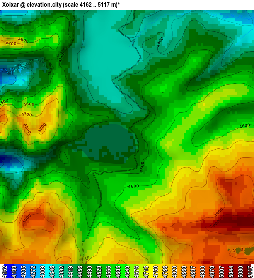
Below is the Elevation map of Xoixar, which displays elevation range with different colors. Scale of the first map is from 4162 to 5117 m (13655 to 16788 ft) with average elevation of 4601.3 meters (=15096 ft) [note 1]
These maps also provides idea of topography and contour of this city, they are displayed at different zoom levels. More info about maps, scale and edge coordinates you can find below images.
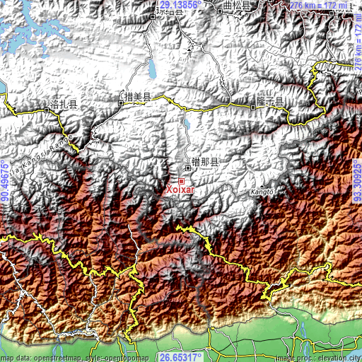
| \ | Map #1 | Topo.Map |
| Scale [m] | 4162..5117 m | × |
| Scale [ft] | 13655..16788 ft | × |
| Average | 4601.3 m = 15096 ft | × |
| Width | 8.64 km = 5.4 mi | 276.3 km = 171.7 mi |
| Height | 8.64 km = 5.4 mi | 276.4 km = 171.7 mi |
| ↑Max Latitude | 27.941829° | 29.13856° |
| Latitude at center | 27.903° | 27.903° |
| ↓Min Latitude | 27.864157° | 26.65317° |
| ← Min Longitude | 91.859055° | 90.49675° |
| Longitude center | 91.903° | 91.903° |
| →Max Longitude | 91.946945° | 93.30925° |
Nearby cities:
Cities around Xoixar sort by population:
• Lhasa elevation 3651 m
209.4 km,  338°
338°
• Dêqên 3974 m
256.3 km,  333°
333°
• Jiangzi 4036 m
252.1 km,  296°
296°
• Mainling 2937 m
268.8 km,  57°
57°
• Xarlung 3754 m
260.4 km,  31°
31°
• Tungdor 2952 m
257.2 km, 55°
• Qiangqinxue 5381 m
247.5 km,  307°
307°
• Kangmar 4289 m
229.7 km,  288°
288°
• Jibenggang 3654 m
209.3 km, 338°
• Konggar 3568 m
178.6 km, 329°
• Nangxian 3327 m
172 km,  42°
42°
• Naidong 3560 m
149.5 km,  355°
355°
Multilingual:
 En español:
Xoixar elevación 4452 m.
 En France:
Xoixar élévation 4452 m.


Sources and notes:
- [note 1] Map square and city borders are not equal. Map elevation data is calculated only from area inside that square.
- [src 1] Elevation data from geonames database provided with same terms of usage.
- [src 2] The elevation map of Xoixar is generated using elevation data from NASA's 3 arcsec (90m) resolution SRTM data.
- [src 3] Base (background) map © OpenStreetMap contributors tiles are generated by Geofabrik and OpenTopoMap.
Copyright & License:
This Xoixar Elevation Map is licensed under CC BY-SA. You may reuse any part from this page, if you give a proper credit by linking to this URL:
 More info on terms of use page.