Jiangzi elevation
Jiangzi (Tibet), China elevation is 4036 meters and Jiangzi elevation in feet is 13241 ft above sea level [src 1]. Jiangzi is a seat of a third-order administrative division (feature code) with elevation that is 3478 meters (11411 ft) bigger than average city elevation in China.
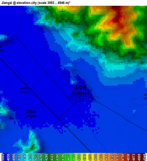
Below is the Elevation map of Jiangzi, which displays elevation range with different colors. Scale of the first map is from 3993 to 4946 m (13100 to 16227 ft) with average elevation of 4121.3 meters (=13521 ft) [note 1]
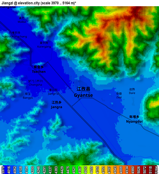
These maps also provides idea of topography and contour of this city, they are displayed at different zoom levels. More info about maps, scale and edge coordinates you can find below images.
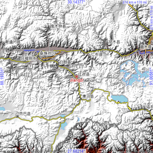
| \ | Map #1 | Map #2 | Topo.Map |
| Scale [m] | 3993..4946 m | 3970..5164 m | × |
| Scale [ft] | 13100..16227 ft | 13025..16942 ft | × |
| Average | 4121.3 m = 13521 ft | 4207.7 m = 13805 ft | × |
| Width | 8.55 km = 5.3 mi | 17.11 km = 10.6 mi | 273.7 km = 170.1 mi |
| Height | 8.55 km = 5.3 mi | 17.11 km = 10.6 mi | 273.7 km = 170.1 mi |
| ↑Max Latitude | 28.958718° | 28.997162° | 30.14377° |
| Latitude at center | 28.92026° | 28.92026° | 28.92026° |
| ↓Min Latitude | 28.881788° | 28.843301° | 27.68214° |
| ← Min Longitude | 89.555615° | 89.511669° | 88.19331° |
| Longitude center | 89.59956° | 89.59956° | 89.59956° |
| →Max Longitude | 89.643505° | 89.687451° | 91.00581° |
Nearby cities:
Cities around Jiangzi sort by population:
• Rikaze elevation 3847 m
78.7 km,  297°
297°
• Dêqên 3974 m
158.6 km,  43°
43°
• Sajia 4643 m
150.8 km,  269°
269°
• Konggar 3568 m
141 km,  72°
72°
• Jiding 3898 m
140.1 km,  290°
290°
• Gangba 4594 m
134.9 km,  234°
234°
• Kambaxoi 4693 m
124.9 km,  236°
236°
• Namling 4004 m
98.1 km,  330°
330°
• Renwu 4690 m
95.5 km,  322°
322°
• Qiangqinxue 5381 m
48.3 km, 37°
• Luobuqiongzi 3970 m
43.6 km,  308°
308°
• Kangmar 4289 m
40.9 km,  168°
168°
Multilingual:
 En español:
Jiangzi elevación 4036 m.
 En France:
Jiangzi élévation 4036 m.
 Auf Deutsch:
Jiangzi höhe über dem Meeresspiegel ist 4036 m.

Sources and notes:
- [note 1] Map square and city borders are not equal. Map elevation data is calculated only from area inside that square.
- [src 1] Elevation data from geonames database provided with same terms of usage.
- [src 2] The elevation map of Jiangzi is generated using elevation data from NASA's 3 arcsec (90m) resolution SRTM data.
- [src 3] Base (background) map © OpenStreetMap contributors tiles are generated by Geofabrik and OpenTopoMap.
Copyright & License:
This Jiangzi Elevation Map is licensed under CC BY-SA. You may reuse any part from this page, if you give a proper credit by linking to this URL:
 More info on terms of use page.