Mainling elevation
Mainling (Tibet), China elevation is 2937 meters and Mainling elevation in feet is 9636 ft above sea level [src 1]. Mainling is a seat of a third-order administrative division (feature code) with elevation that is 2379 meters (7805 ft) bigger than average city elevation in China.
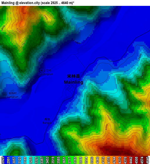
Below is the Elevation map of Mainling, which displays elevation range with different colors. Scale of the first map is from 2925 to 4640 m (9596 to 15223 ft) with average elevation of 3315.5 meters (=10878 ft) [note 1]
These maps also provides idea of topography and contour of this city, they are displayed at different zoom levels. More info about maps, scale and edge coordinates you can find below images.
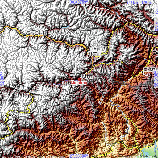
| \ | Map #1 | Topo.Map |
| Scale [m] | 2925..4640 m | × |
| Scale [ft] | 9596..15223 ft | × |
| Average | 3315.5 m = 10878 ft | × |
| Width | 8.53 km = 5.3 mi | 272.9 km = 169.6 mi |
| Height | 8.53 km = 5.3 mi | 272.9 km = 169.6 mi |
| ↑Max Latitude | 29.256017° | 30.43759° |
| Latitude at center | 29.21767° | 29.21767° |
| ↓Min Latitude | 29.179309° | 27.98305° |
| ← Min Longitude | 94.169305° | 92.807° |
| Longitude center | 94.21325° | 94.21325° |
| →Max Longitude | 94.257195° | 95.6195° |
Nearby cities:
Cities around Mainling sort by population:
• Biru elevation 3926 m
257.1 km,  348°
348°
• Biruxong 4582 m
249.8 km, 346°
• Naidong 3560 m
236.9 km,  270°
270°
• Zito 3728 m
230.3 km,  42°
42°
• Domartang 4309 m
196.8 km,  13°
13°
• Coka 3751 m
192.7 km, 13°
• Zhamog 2736 m
166 km,  64°
64°
• Xarlung 3754 m
116.4 km,  310°
310°
• Nangxian 3327 m
110.9 km,  260°
260°
• Motuo 977 m
106.7 km,  84°
84°
• Yinla 3017 m
47.8 km,  33°
33°
• Tungdor 2952 m
12.8 km, 261°
Multilingual:
 En español:
Mainling elevación 2937 m.
 En France:
Mainling élévation 2937 m.
 Auf Deutsch:
Mainling höhe über dem Meeresspiegel ist 2937 m.

Sources and notes:
- [note 1] Map square and city borders are not equal. Map elevation data is calculated only from area inside that square.
- [src 1] Elevation data from geonames database provided with same terms of usage.
- [src 2] The elevation map of Mainling is generated using elevation data from NASA's 3 arcsec (90m) resolution SRTM data.
- [src 3] Base (background) map © OpenStreetMap contributors tiles are generated by Geofabrik and OpenTopoMap.
Copyright & License:
This Mainling Elevation Map is licensed under CC BY-SA. You may reuse any part from this page, if you give a proper credit by linking to this URL:
 More info on terms of use page.