Domartang elevation
Domartang (Tibet), China elevation is 4309 meters and Domartang elevation in feet is 14137 ft above sea level [src 1]. Domartang is a seat of a third-order administrative division (feature code) with elevation that is 3751 meters (12306 ft) bigger than average city elevation in China.
Below is the Elevation map of Domartang, which displays elevation range with different colors. Scale of the first map is from 3592 to 5075 m (11785 to 16650 ft) with average elevation of 4233.5 meters (=13889 ft) [note 1]
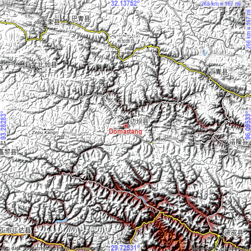
These maps also provides idea of topography and contour of this city, they are displayed at different zoom levels. More info about maps, scale and edge coordinates you can find below images.
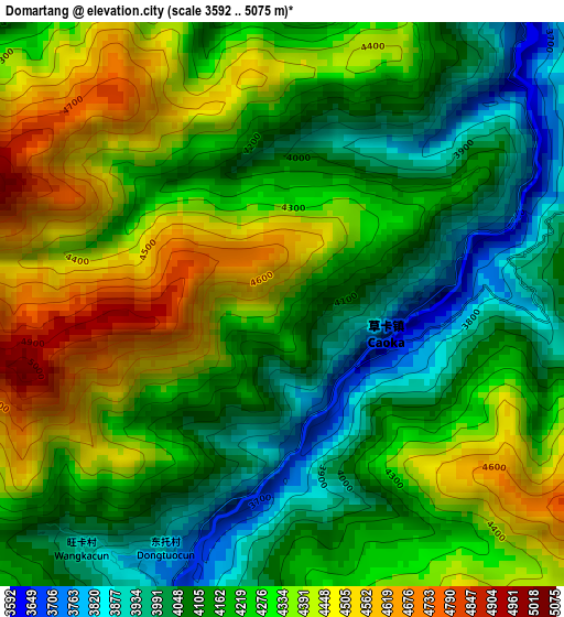
| \ | Map #1 | Topo.Map |
| Scale [m] | 3592..5075 m | × |
| Scale [ft] | 11785..16650 ft | × |
| Average | 4233.5 m = 13889 ft | × |
| Width | 8.38 km = 5.2 mi | 268.2 km = 166.7 mi |
| Height | 8.38 km = 5.2 mi | 268.2 km = 166.7 mi |
| ↑Max Latitude | 30.976705° | 32.13752° |
| Latitude at center | 30.93902° | 30.93902° |
| ↓Min Latitude | 30.90132° | 29.72531° |
| ← Min Longitude | 94.645135° | 93.28283° |
| Longitude center | 94.68908° | 94.68908° |
| →Max Longitude | 94.733025° | 96.09533° |
Nearby cities:
Cities around Domartang sort by population:
• Xarlung elevation 3754 m
176.3 km,  229°
229°
• Zhamog 2736 m
157.3 km,  139°
139°
• Yinla 3017 m
152.7 km,  187°
187°
• Zaindainxoi 4134 m
140.3 km,  316°
316°
• Dartang 4138 m
128.4 km,  329°
329°
• Laxi 4144 m
125 km, 330°
• Biruxong 4582 m
115.6 km,  296°
296°
• Biru 3926 m
113.7 km, 302°
• Zito 3728 m
111.7 km,  101°
101°
• Dingqing 3878 m
100.1 km,  58°
58°
• Gyamotang 4955 m
96.8 km,  46°
46°
• Coka 3751 m
4.2 km,  206°
206°
Multilingual:
 En español:
Domartang elevación 4309 m.
 En France:
Domartang élévation 4309 m.
 Auf Deutsch:
Domartang höhe über dem Meeresspiegel ist 4309 m.

Sources and notes:
- [note 1] Map square and city borders are not equal. Map elevation data is calculated only from area inside that square.
- [src 1] Elevation data from geonames database provided with same terms of usage.
- [src 2] The elevation map of Domartang is generated using elevation data from NASA's 3 arcsec (90m) resolution SRTM data.
- [src 3] Base (background) map © OpenStreetMap contributors tiles are generated by Geofabrik and OpenTopoMap.
Copyright & License:
This Domartang Elevation Map is licensed under CC BY-SA. You may reuse any part from this page, if you give a proper credit by linking to this URL:
 More info on terms of use page.