Galutu elevation
Galutu (Inner Mongolia), China elevation is 1303 meters and Galutu elevation in feet is 4275 ft above sea level [src 1]. Galutu is a seat of a third-order administrative division (feature code) with elevation that is 745 meters (2444 ft) bigger than average city elevation in China.
Below is the Elevation map of Galutu, which displays elevation range with different colors. Scale of the first map is from 1280 to 1345 m (4199 to 4413 ft) with average elevation of 1303.9 meters (=4278 ft) [note 1]
These maps also provides idea of topography and contour of this city, they are displayed at different zoom levels. More info about maps, scale and edge coordinates you can find below images.
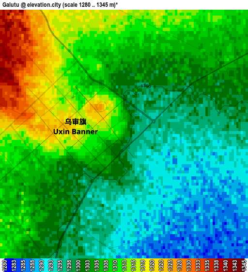
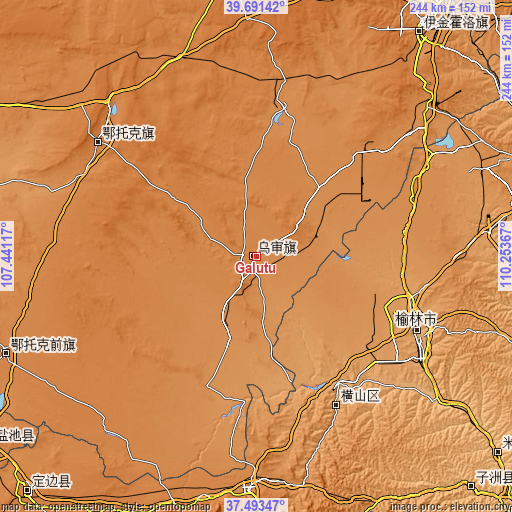
| \ | Map #1 | Topo.Map |
| Scale [m] | 1280..1345 m | × |
| Scale [ft] | 4199..4413 ft | × |
| Average | 1303.9 m = 4278 ft | × |
| Width | 7.64 km = 4.7 mi | 244.4 km = 151.9 mi |
| Height | 7.64 km = 4.7 mi | 244.4 km = 151.9 mi |
| ↑Max Latitude | 38.635196° | 39.69142° |
| Latitude at center | 38.60086° | 38.60086° |
| ↓Min Latitude | 38.566508° | 37.49347° |
| ← Min Longitude | 108.803475° | 107.44117° |
| Longitude center | 108.84742° | 108.84742° |
| →Max Longitude | 108.891365° | 110.25367° |
Nearby cities:
Cities around Galutu sort by population:
• Ordos elevation 1310 m
138 km,  35°
35°
• Dongsheng 1439 m
166.5 km, 35°
• Yulinshi 1056 m
84.8 km,  113°
113°
• Beijie 1094 m
192.9 km,  291°
291°
• Tianjiao 1440 m
168.5 km, 36°
• Dingbian 1374 m
156.8 km,  224°
224°
• Huamachi 1352 m
155.4 km,  234°
234°
• Xinli 1362 m
138.6 km,  355°
355°
• Aletengxire 1304 m
134.3 km, 35°
• Oljoq 1343 m
128.4 km,  248°
248°
• Zhangjiapan 1335 m
111.2 km,  182°
182°
• Ulan 1375 m
93 km,  306°
306°
Multilingual:
 En español:
Galutu elevación 1303 m.
 En France:
Galutu élévation 1303 m.


Sources and notes:
- [note 1] Map square and city borders are not equal. Map elevation data is calculated only from area inside that square.
- [src 1] Elevation data from geonames database provided with same terms of usage.
- [src 2] The elevation map of Galutu is generated using elevation data from NASA's 3 arcsec (90m) resolution SRTM data.
- [src 3] Base (background) map © OpenStreetMap contributors tiles are generated by Geofabrik and OpenTopoMap.
Copyright & License:
This Galutu Elevation Map is licensed under CC BY-SA. You may reuse any part from this page, if you give a proper credit by linking to this URL:
 More info on terms of use page.