Dingbian elevation
Dingbian (Shaanxi), China elevation is 1374 meters and Dingbian elevation in feet is 4508 ft above sea level [src 1]. Dingbian is a seat of a third-order administrative division (feature code) with elevation that is 816 meters (2677 ft) bigger than average city elevation in China.
Below is the Elevation map of Dingbian, which displays elevation range with different colors. Scale of the first map is from 1353 to 1397 m (4439 to 4583 ft) with average elevation of 1373.7 meters (=4507 ft) [note 1]
These maps also provides idea of topography and contour of this city, they are displayed at different zoom levels. More info about maps, scale and edge coordinates you can find below images.
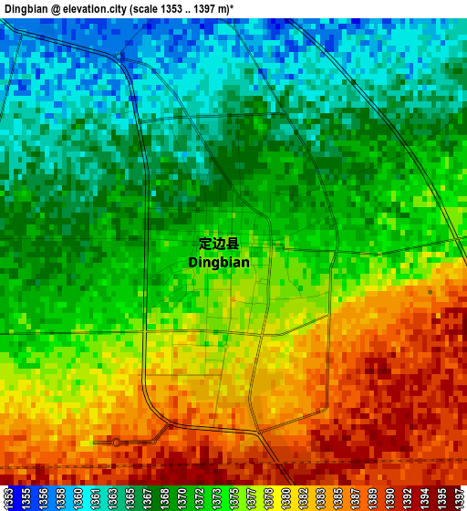
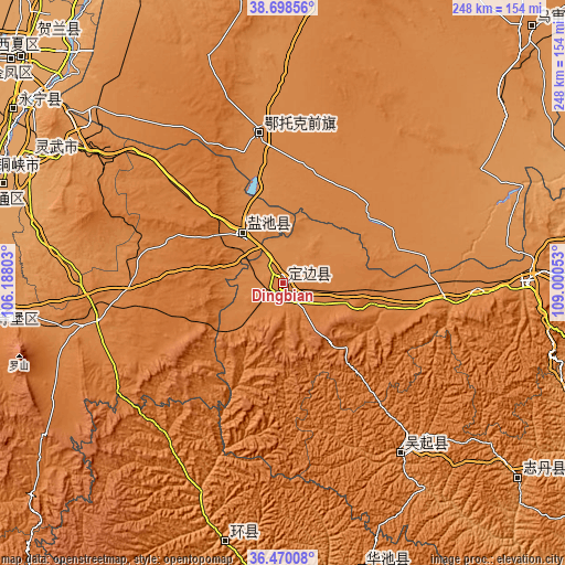
| \ | Map #1 | Topo.Map |
| Scale [m] | 1353..1397 m | × |
| Scale [ft] | 4439..4583 ft | × |
| Average | 1373.7 m = 4507 ft | × |
| Width | 7.74 km = 4.8 mi | 247.8 km = 154 mi |
| Height | 7.74 km = 4.8 mi | 247.8 km = 154 mi |
| ↑Max Latitude | 37.627473° | 38.69856° |
| Latitude at center | 37.59266° | 37.59266° |
| ↓Min Latitude | 37.557831° | 36.47008° |
| ← Min Longitude | 107.550335° | 106.18803° |
| Longitude center | 107.59428° | 107.59428° |
| →Max Longitude | 107.638225° | 109.00053° |
Nearby cities:
Cities around Dingbian sort by population:
• Yinchuan elevation 1117 m
151.2 km,  310°
310°
• Xigang 1111 m
152.6 km, 314°
• Yanghe 1123 m
140.6 km,  302°
302°
• Hongsipu 1338 m
137 km,  260°
260°
• Bao’an 1233 m
133.5 km,  129°
129°
• Shengli 1134 m
130.3 km,  289°
289°
• Wuzhong 1133 m
130 km, 289°
• Dongta 1122 m
122.5 km, 296°
• Zhangjiapan 1335 m
106 km,  89°
89°
• Wuqi 1298 m
90 km,  145°
145°
• Oljoq 1343 m
66.1 km,  350°
350°
• Huamachi 1352 m
27.2 km,  321°
321°
Multilingual:
 En español:
Dingbian elevación 1374 m.
 En France:
Dingbian élévation 1374 m.
 Auf Deutsch:
Dingbian höhe über dem Meeresspiegel ist 1374 m.

Sources and notes:
- [note 1] Map square and city borders are not equal. Map elevation data is calculated only from area inside that square.
- [src 1] Elevation data from geonames database provided with same terms of usage.
- [src 2] The elevation map of Dingbian is generated using elevation data from NASA's 3 arcsec (90m) resolution SRTM data.
- [src 3] Base (background) map © OpenStreetMap contributors tiles are generated by Geofabrik and OpenTopoMap.
Copyright & License:
This Dingbian Elevation Map is licensed under CC BY-SA. You may reuse any part from this page, if you give a proper credit by linking to this URL:
 More info on terms of use page.