Dongta elevation
Dongta (Ningxia Hui Autonomous Region), China elevation is 1122 meters and Dongta elevation in feet is 3681 ft above sea level [src 1]. Dongta is a seat of a third-order administrative division (feature code) with elevation that is 564 meters (1850 ft) bigger than average city elevation in China.
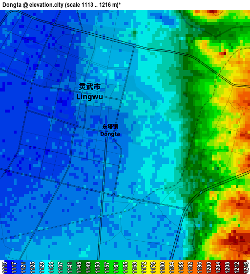
Below is the Elevation map of Dongta, which displays elevation range with different colors. Scale of the first map is from 1113 to 1216 m (3652 to 3990 ft) with average elevation of 1134.9 meters (=3723 ft) [note 1]
These maps also provides idea of topography and contour of this city, they are displayed at different zoom levels. More info about maps, scale and edge coordinates you can find below images.
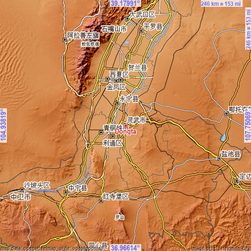
| \ | Map #1 | Topo.Map |
| Scale [m] | 1113..1216 m | × |
| Scale [ft] | 3652..3990 ft | × |
| Average | 1134.9 m = 3723 ft | × |
| Width | 7.69 km = 4.8 mi | 246.1 km = 152.9 mi |
| Height | 7.69 km = 4.8 mi | 246.1 km = 152.9 mi |
| ↑Max Latitude | 38.115983° | 39.17991° |
| Latitude at center | 38.0814° | 38.0814° |
| ↓Min Latitude | 38.046801° | 36.96614° |
| ← Min Longitude | 106.300495° | 104.93819° |
| Longitude center | 106.34444° | 106.34444° |
| →Max Longitude | 106.388385° | 107.75069° |
Nearby cities:
Cities around Dongta sort by population:
• Yinchuan elevation 1117 m
43.4 km,  351°
351°
• Dawukou 1119 m
106.9 km,  2°
2°
• Bayan Hot 1529 m
102.7 km,  325°
325°
• Oljoq 1343 m
99.5 km,  83°
83°
• Huamachi 1352 m
98.5 km,  109°
109°
• Pingluo Chengguanzhen 1102 m
93 km,  10°
10°
• Ning’an 1187 m
87.5 km,  222°
222°
• Hongsipu 1338 m
79.9 km,  198°
198°
• Xigang 1111 m
52.4 km, 0°
• Yanghe 1123 m
23.5 km,  338°
338°
• Shengli 1134 m
16.9 km,  230°
230°
• Wuzhong 1133 m
16.4 km, 230°
Multilingual:
 En español:
Dongta elevación 1122 m.
 En France:
Dongta élévation 1122 m.


Sources and notes:
- [note 1] Map square and city borders are not equal. Map elevation data is calculated only from area inside that square.
- [src 1] Elevation data from geonames database provided with same terms of usage.
- [src 2] The elevation map of Dongta is generated using elevation data from NASA's 3 arcsec (90m) resolution SRTM data.
- [src 3] Base (background) map © OpenStreetMap contributors tiles are generated by Geofabrik and OpenTopoMap.
Copyright & License:
This Dongta Elevation Map is licensed under CC BY-SA. You may reuse any part from this page, if you give a proper credit by linking to this URL:
 More info on terms of use page.