Heihe elevation
Heihe (Heilongjiang), China elevation is 139 meters and Heihe elevation in feet is 456 ft above sea level [src 1]. Heihe is a populated place (feature code) with elevation that is 419 meters (1375 ft) smaller than average city elevation in China.
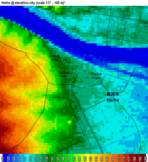
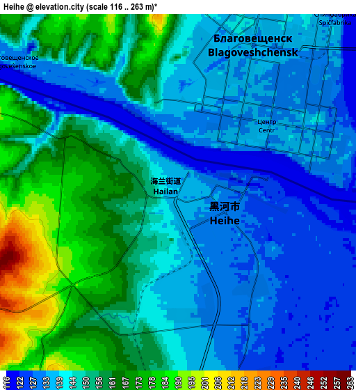
Below is the Elevation map of Heihe, which displays elevation range with different colors. Scale of the first map is from 117 to 185 m (384 to 607 ft) with average elevation of 139.3 meters (=457 ft) [note 1]
These maps also provides idea of topography and contour of this city, they are displayed at different zoom levels. More info about maps, scale and edge coordinates you can find below images.
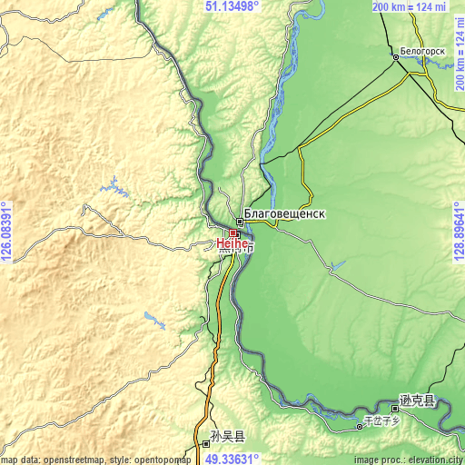
| \ | Map #1 | Map #2 | Topo.Map |
| Scale [m] | 117..185 m | 116..263 m | × |
| Scale [ft] | 384..607 ft | 381..863 ft | × |
| Average | 139.3 m = 457 ft | 147.2 m = 483 ft | × |
| Width | 6.25 km = 3.9 mi | 12.5 km = 7.8 mi | 200 km = 124.3 mi |
| Height | 6.25 km = 3.9 mi | 12.5 km = 7.8 mi | 200 km = 124.3 mi |
| ↑Max Latitude | 50.272226° | 50.300304° | 51.13498° |
| Latitude at center | 50.24413° | 50.24413° | 50.24413° |
| ↓Min Latitude | 50.216018° | 50.187889° | 49.33631° |
| ← Min Longitude | 127.446215° | 127.402269° | 126.08391° |
| Longitude center | 127.49016° | 127.49016° | 127.49016° |
| →Max Longitude | 127.534105° | 127.578051° | 128.89641° |
Nearby cities:
Cities around Heihe sort by population:
• Bei’an elevation 273 m
229.2 km,  196°
196°
• Jiagedaqi 381 m
240.2 km,  274°
274°
• Nehe 197 m
274.5 km,  224°
224°
• Nenjiang 229 m
202.1 km,  233°
233°
• Oroqen Zizhiqi 419 m
269.8 km,  277°
277°
• Xinqing 311 m
262.9 km,  145°
145°
• Xinlin 576 m
273.9 km,  306°
306°
• Chaoyang 85 m
258.7 km,  125°
125°
• Khuma 174 m
174.4 km,  339°
339°
• Bianjiang 132 m
103.8 km,  137°
137°
• Sunwu 232 m
92.8 km,  187°
187°
• Xing’an 133 m
0.5 km,  28°
28°
Multilingual:
 En español:
Heihe elevación 139 m.
 En France:
Heihe élévation 139 m.


Sources and notes:
- [note 1] Map square and city borders are not equal. Map elevation data is calculated only from area inside that square.
- [src 1] Elevation data from geonames database provided with same terms of usage.
- [src 2] The elevation map of Heihe is generated using elevation data from NASA's 3 arcsec (90m) resolution SRTM data.
- [src 3] Base (background) map © OpenStreetMap contributors tiles are generated by Geofabrik and OpenTopoMap.
Copyright & License:
This Heihe Elevation Map is licensed under CC BY-SA. You may reuse any part from this page, if you give a proper credit by linking to this URL:
 More info on terms of use page.