Sunwu elevation
Sunwu (Heilongjiang), China elevation is 232 meters and Sunwu elevation in feet is 761 ft above sea level [src 1]. Sunwu is a seat of a third-order administrative division (feature code) with elevation that is 326 meters (1070 ft) smaller than average city elevation in China.
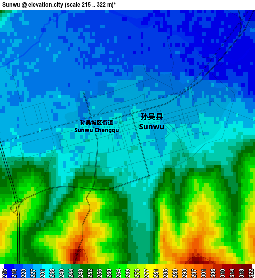
Below is the Elevation map of Sunwu, which displays elevation range with different colors. Scale of the first map is from 215 to 322 m (705 to 1056 ft) with average elevation of 241.1 meters (=791 ft) [note 1]
These maps also provides idea of topography and contour of this city, they are displayed at different zoom levels. More info about maps, scale and edge coordinates you can find below images.
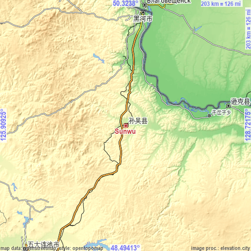
| \ | Map #1 | Topo.Map |
| Scale [m] | 215..322 m | × |
| Scale [ft] | 705..1056 ft | × |
| Average | 241.1 m = 791 ft | × |
| Width | 6.36 km = 4 mi | 203.4 km = 126.4 mi |
| Height | 6.36 km = 4 mi | 203.4 km = 126.4 mi |
| ↑Max Latitude | 49.44607° | 50.3238° |
| Latitude at center | 49.41749° | 49.41749° |
| ↓Min Latitude | 49.388893° | 48.49413° |
| ← Min Longitude | 127.271555° | 125.90925° |
| Longitude center | 127.3155° | 127.3155° |
| →Max Longitude | 127.359445° | 128.72175° |
Nearby cities:
Cities around Sunwu sort by population:
• Bei’an elevation 273 m
138.3 km,  202°
202°
• Hailun 242 m
219.7 km,  186°
186°
• Heihe 139 m
92.8 km,  7°
7°
• Nehe 197 m
208.9 km,  240°
240°
• Nenjiang 229 m
154.5 km,  259°
259°
• Youhao 238 m
206.7 km,  147°
147°
• Xinqing 311 m
204.7 km,  127°
127°
• Wumahe 244 m
217.5 km, 150°
• Shuguang 253 m
213.2 km, 152°
• Hongshan 285 m
203.4 km,  142°
142°
• Xing’an 133 m
93.2 km, 7°
• Bianjiang 132 m
85.1 km,  79°
79°
Multilingual:
 En español:
Sunwu elevación 232 m.
 En France:
Sunwu élévation 232 m.


Sources and notes:
- [note 1] Map square and city borders are not equal. Map elevation data is calculated only from area inside that square.
- [src 1] Elevation data from geonames database provided with same terms of usage.
- [src 2] The elevation map of Sunwu is generated using elevation data from NASA's 3 arcsec (90m) resolution SRTM data.
- [src 3] Base (background) map © OpenStreetMap contributors tiles are generated by Geofabrik and OpenTopoMap.
Copyright & License:
This Sunwu Elevation Map is licensed under CC BY-SA. You may reuse any part from this page, if you give a proper credit by linking to this URL:
 More info on terms of use page.