Nehe elevation
Nehe (Heilongjiang), China elevation is 197 meters and Nehe elevation in feet is 646 ft above sea level [src 1]. Nehe is a populated place (feature code) with elevation that is 361 meters (1184 ft) smaller than average city elevation in China.
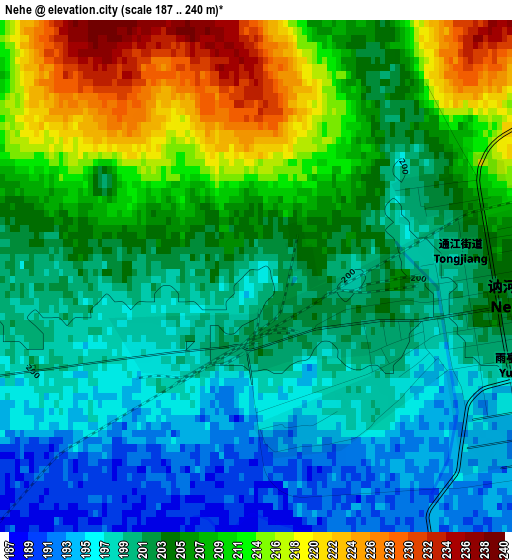
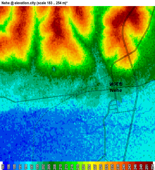
Below is the Elevation map of Nehe, which displays elevation range with different colors. Scale of the first map is from 187 to 240 m (614 to 787 ft) with average elevation of 204.8 meters (=672 ft) [note 1]
These maps also provides idea of topography and contour of this city, they are displayed at different zoom levels. More info about maps, scale and edge coordinates you can find below images.
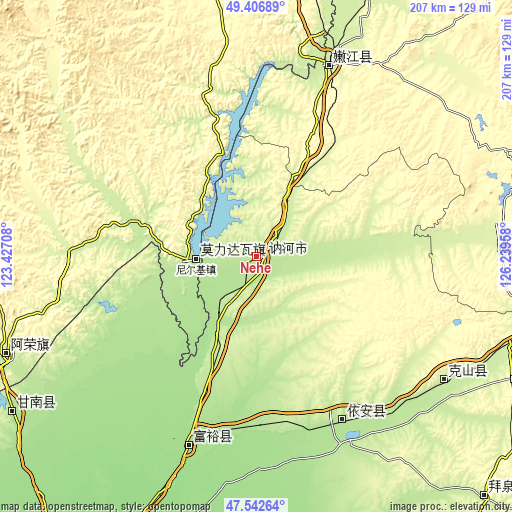
| \ | Map #1 | Map #2 | Topo.Map |
| Scale [m] | 187..240 m | 183..254 m | × |
| Scale [ft] | 614..787 ft | 600..833 ft | × |
| Average | 204.8 m = 672 ft | 207.8 m = 682 ft | × |
| Width | 6.48 km = 4 mi | 12.96 km = 8.1 mi | 207.3 km = 128.8 mi |
| Height | 6.48 km = 4 mi | 12.96 km = 8.1 mi | 207.3 km = 128.8 mi |
| ↑Max Latitude | 48.51245° | 48.541554° | 49.40689° |
| Latitude at center | 48.48333° | 48.48333° | 48.48333° |
| ↓Min Latitude | 48.454193° | 48.425039° | 47.54264° |
| ← Min Longitude | 124.789385° | 124.745439° | 123.42708° |
| Longitude center | 124.83333° | 124.83333° | 124.83333° |
| →Max Longitude | 124.877275° | 124.921221° | 126.23958° |
Nearby cities:
Cities around Nehe sort by population:
• Qiqihar elevation 151 m
142.7 km,  207°
207°
• Bei’an 273 m
132.7 km,  100°
100°
• Nenjiang 229 m
81.8 km,  20°
20°
• Fuyu 168 m
81.2 km,  200°
200°
• Baiquan 237 m
134.8 km,  136°
136°
• Gannan 188 m
117.1 km,  237°
237°
• Lindian 155 m
144.7 km,  178°
178°
• Longhua 151 m
142.3 km, 206°
• Bukui 156 m
141.6 km, 207°
• Naji 218 m
109.3 km,  248°
248°
• Yi’an 205 m
74.7 km,  152°
152°
• Nirji 195 m
25.8 km,  270°
270°
Multilingual:
 En español:
Nehe elevación 197 m.
 En France:
Nehe élévation 197 m.


Sources and notes:
- [note 1] Map square and city borders are not equal. Map elevation data is calculated only from area inside that square.
- [src 1] Elevation data from geonames database provided with same terms of usage.
- [src 2] The elevation map of Nehe is generated using elevation data from NASA's 3 arcsec (90m) resolution SRTM data.
- [src 3] Base (background) map © OpenStreetMap contributors tiles are generated by Geofabrik and OpenTopoMap.
Copyright & License:
This Nehe Elevation Map is licensed under CC BY-SA. You may reuse any part from this page, if you give a proper credit by linking to this URL:
 More info on terms of use page.