Songyuan elevation
Songyuan (Jilin, Songyuan Shi), China elevation is 134 meters and Songyuan elevation in feet is 440 ft above sea level [src 1]. Songyuan is a seat of a second-order administrative division (feature code) with elevation that is 424 meters (1391 ft) smaller than average city elevation in China.
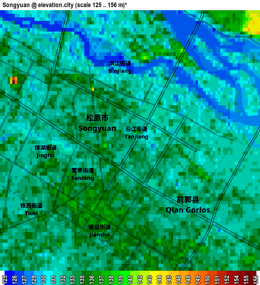
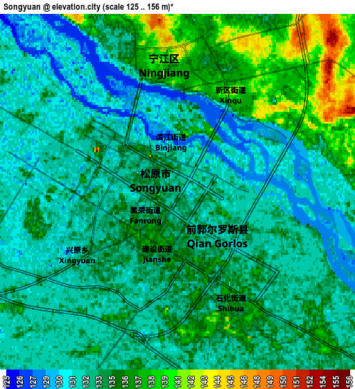
Below is the Elevation map of Songyuan, which displays elevation range with different colors. Scale of the first map is from 125 to 156 m (410 to 512 ft) with average elevation of 132.5 meters (=435 ft) [note 1]
These maps also provides idea of topography and contour of this city, they are displayed at different zoom levels. More info about maps, scale and edge coordinates you can find below images.
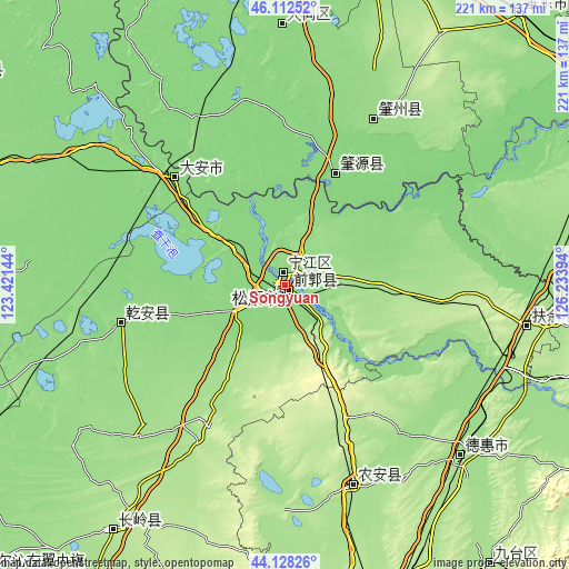
| \ | Map #1 | Map #2 | Topo.Map |
| Scale [m] | 125..156 m | 125..156 m | × |
| Scale [ft] | 410..512 ft | 410..512 ft | × |
| Average | 132.5 m = 435 ft | 133.6 m = 438 ft | × |
| Width | 6.89 km = 4.3 mi | 13.79 km = 8.6 mi | 220.6 km = 137.1 mi |
| Height | 6.89 km = 4.3 mi | 13.79 km = 8.6 mi | 220.6 km = 137.1 mi |
| ↑Max Latitude | 45.160016° | 45.190994° | 46.11252° |
| Latitude at center | 45.12902° | 45.12902° | 45.12902° |
| ↓Min Latitude | 45.098008° | 45.066978° | 44.12826° |
| ← Min Longitude | 124.783745° | 124.739799° | 123.42144° |
| Longitude center | 124.82769° | 124.82769° | 124.82769° |
| →Max Longitude | 124.871635° | 124.915581° | 126.23394° |
Nearby cities:
Cities around Songyuan sort by population:
• Jiutai elevation 180 m
134.6 km,  143°
143°
• Fuyu 141 m
6.1 km,  351°
351°
• Shuangcheng 163 m
116.6 km,  77°
77°
• Dehui 180 m
95.5 km,  133°
133°
• Dalai 137 m
58.3 km,  314°
314°
• Zhaozhou 152 m
72.5 km,  31°
31°
• Zhaoyuan 127 m
47.7 km, 30°
• Changling 190 m
116.2 km,  214°
214°
• Datong 135 m
100.6 km,  359°
359°
• Sanchahe 197 m
95.1 km,  101°
101°
• Nong’an 171 m
87.3 km,  162°
162°
• Qian’an 143 m
62.3 km,  255°
255°
Multilingual:
 En español:
Songyuan elevación 134 m.
 En France:
Songyuan élévation 134 m.
 Auf Deutsch:
Songyuan höhe über dem Meeresspiegel ist 134 m.

Sources and notes:
- [note 1] Map square and city borders are not equal. Map elevation data is calculated only from area inside that square.
- [src 1] Elevation data from geonames database provided with same terms of usage.
- [src 2] The elevation map of Songyuan is generated using elevation data from NASA's 3 arcsec (90m) resolution SRTM data.
- [src 3] Base (background) map © OpenStreetMap contributors tiles are generated by Geofabrik and OpenTopoMap.
Copyright & License:
This Songyuan Elevation Map is licensed under CC BY-SA. You may reuse any part from this page, if you give a proper credit by linking to this URL:
 More info on terms of use page.