Qian’an elevation
Qian’an (Jilin), China elevation is 143 meters and Qian’an elevation in feet is 469 ft above sea level [src 1]. Qian’an is a seat of a third-order administrative division (feature code) with elevation that is 415 meters (1362 ft) smaller than average city elevation in China.
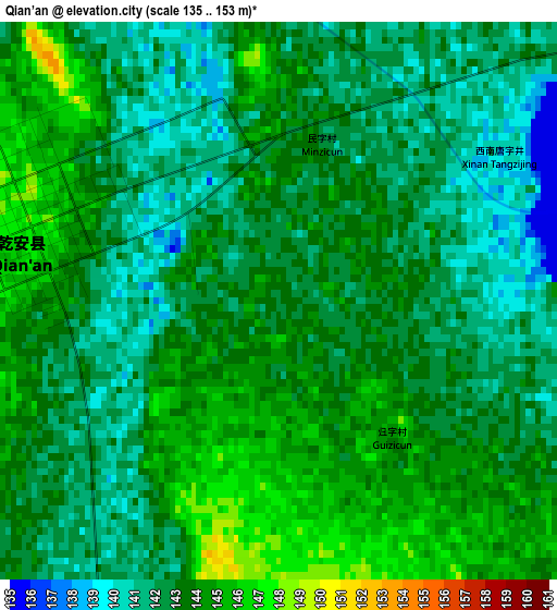
Below is the Elevation map of Qian’an, which displays elevation range with different colors. Scale of the first map is from 135 to 153 m (443 to 502 ft) with average elevation of 142.7 meters (=468 ft) [note 1]
These maps also provides idea of topography and contour of this city, they are displayed at different zoom levels. More info about maps, scale and edge coordinates you can find below images.
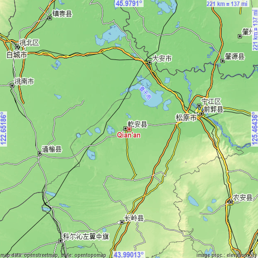
| \ | Map #1 | Topo.Map |
| Scale [m] | 135..153 m | × |
| Scale [ft] | 443..502 ft | × |
| Average | 142.7 m = 468 ft | × |
| Width | 6.91 km = 4.3 mi | 221.2 km = 137.4 mi |
| Height | 6.91 km = 4.3 mi | 221.1 km = 137.4 mi |
| ↑Max Latitude | 45.024309° | 45.9791° |
| Latitude at center | 44.99324° | 44.99324° |
| ↓Min Latitude | 44.962154° | 43.99013° |
| ← Min Longitude | 124.014165° | 122.65186° |
| Longitude center | 124.05811° | 124.05811° |
| →Max Longitude | 124.102055° | 125.46436° |
Nearby cities:
Cities around Qian’an sort by population:
• Baicheng elevation 152 m
118.4 km,  305°
305°
• Fuyu 141 m
63.2 km,  70°
70°
• Songyuan 134 m
62.3 km,  75°
75°
• Guangming 150 m
106.9 km,  290°
290°
• Dalai 137 m
59.4 km,  18°
18°
• Zhenlai 135 m
112.2 km,  328°
328°
• Kaitong 145 m
74.3 km,  254°
254°
• Zhaoyuan 127 m
101.3 km,  56°
56°
• Changling 190 m
81.1 km,  183°
183°
• Mingren 150 m
117.7 km,  304°
304°
• Baokang 146 m
114 km,  211°
211°
• Nong’an 171 m
111 km,  127°
127°
Multilingual:
 En español:
Qian’an elevación 143 m.
 En France:
Qian’an élévation 143 m.


Sources and notes:
- [note 1] Map square and city borders are not equal. Map elevation data is calculated only from area inside that square.
- [src 1] Elevation data from geonames database provided with same terms of usage.
- [src 2] The elevation map of Qian’an is generated using elevation data from NASA's 3 arcsec (90m) resolution SRTM data.
- [src 3] Base (background) map © OpenStreetMap contributors tiles are generated by Geofabrik and OpenTopoMap.
Copyright & License:
This Qian’an Elevation Map is licensed under CC BY-SA. You may reuse any part from this page, if you give a proper credit by linking to this URL:
 More info on terms of use page.