Jiutai elevation
Jiutai (Jilin), China elevation is 180 meters and Jiutai elevation in feet is 591 ft above sea level [src 1]. Jiutai is a populated place (feature code) with elevation that is 378 meters (1240 ft) smaller than average city elevation in China.
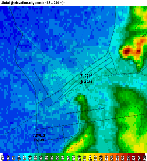
Below is the Elevation map of Jiutai, which displays elevation range with different colors. Scale of the first map is from 165 to 244 m (541 to 801 ft) with average elevation of 179.6 meters (=589 ft) [note 1]
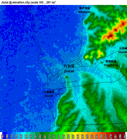
These maps also provides idea of topography and contour of this city, they are displayed at different zoom levels. More info about maps, scale and edge coordinates you can find below images.
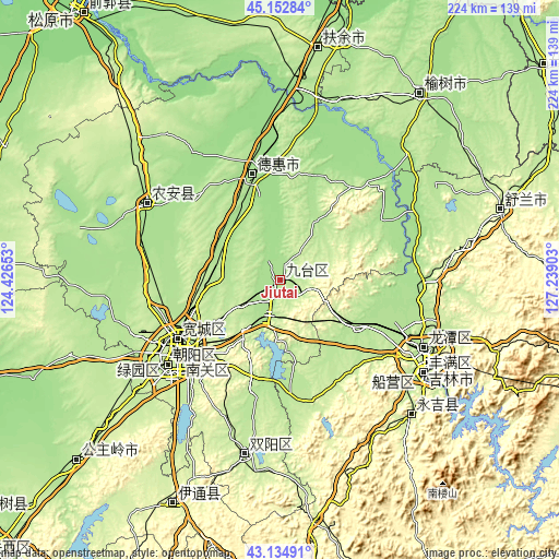
| \ | Map #1 | Map #2 | Topo.Map |
| Scale [m] | 165..244 m | 163..291 m | × |
| Scale [ft] | 541..801 ft | 535..955 ft | × |
| Average | 179.6 m = 589 ft | 183.5 m = 602 ft | × |
| Width | 7.01 km = 4.4 mi | 14.02 km = 8.7 mi | 224.4 km = 139.4 mi |
| Height | 7.01 km = 4.4 mi | 14.02 km = 8.7 mi | 224.4 km = 139.4 mi |
| ↑Max Latitude | 44.184022° | 44.215527° | 45.15284° |
| Latitude at center | 44.1525° | 44.1525° | 44.1525° |
| ↓Min Latitude | 44.120961° | 44.089406° | 43.13491° |
| ← Min Longitude | 125.788835° | 125.744889° | 124.42653° |
| Longitude center | 125.83278° | 125.83278° | 125.83278° |
| →Max Longitude | 125.876725° | 125.920671° | 127.23903° |
Nearby cities:
Cities around Jiutai sort by population:
• Changchun elevation 206 m
50.8 km,  233°
233°
• Jilin 196 m
67.2 km,  119°
119°
• Yushu 220 m
91 km,  37°
37°
• Dehui 180 m
43.6 km,  345°
345°
• Jishu 250 m
79.2 km,  76°
76°
• Shulan 233 m
93.7 km,  71°
71°
• Shuangyang 210 m
71 km,  190°
190°
• Xinglongshan 228 m
36.5 km, 233°
• Yantongshan 250 m
96.7 km,  171°
171°
• Sanchahe 197 m
91.3 km,  9°
9°
• Kouqian 240 m
75.9 km,  138°
138°
• Nong’an 171 m
58.7 km,  295°
295°
Multilingual:
 En español:
Jiutai elevación 180 m.
 En France:
Jiutai élévation 180 m.


Sources and notes:
- [note 1] Map square and city borders are not equal. Map elevation data is calculated only from area inside that square.
- [src 1] Elevation data from geonames database provided with same terms of usage.
- [src 2] The elevation map of Jiutai is generated using elevation data from NASA's 3 arcsec (90m) resolution SRTM data.
- [src 3] Base (background) map © OpenStreetMap contributors tiles are generated by Geofabrik and OpenTopoMap.
Copyright & License:
This Jiutai Elevation Map is licensed under CC BY-SA. You may reuse any part from this page, if you give a proper credit by linking to this URL:
 More info on terms of use page.