Xinglongshan elevation
Xinglongshan (Jilin), China elevation is 228 meters and Xinglongshan elevation in feet is 748 ft above sea level [src 1]. Xinglongshan is a populated place (feature code) with elevation that is 330 meters (1083 ft) smaller than average city elevation in China.
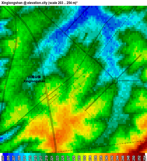
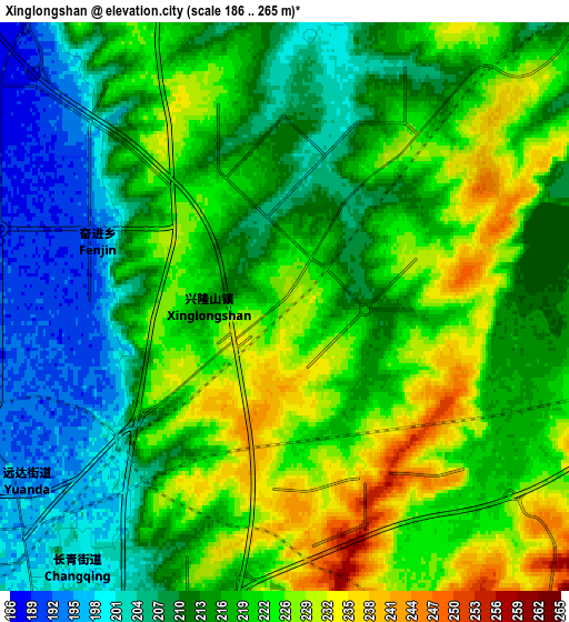
Below is the Elevation map of Xinglongshan, which displays elevation range with different colors. Scale of the first map is from 203 to 254 m (666 to 833 ft) with average elevation of 222.4 meters (=730 ft) [note 1]
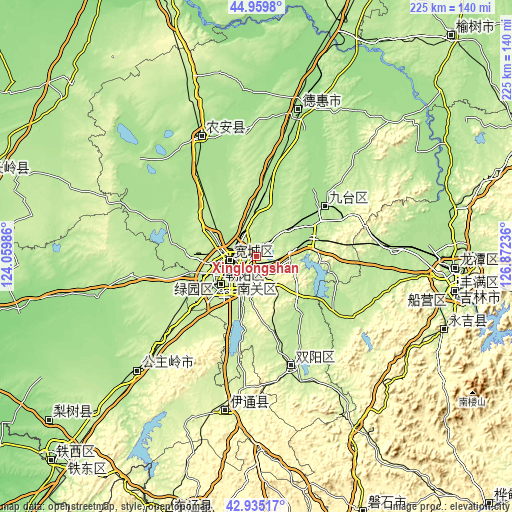
These maps also provides idea of topography and contour of this city, they are displayed at different zoom levels. More info about maps, scale and edge coordinates you can find below images.
| \ | Map #1 | Map #2 | Topo.Map |
| Scale [m] | 203..254 m | 186..265 m | × |
| Scale [ft] | 666..833 ft | 610..869 ft | × |
| Average | 222.4 m = 730 ft | 217.3 m = 713 ft | × |
| Width | 7.03 km = 4.4 mi | 14.07 km = 8.7 mi | 225.1 km = 139.9 mi |
| Height | 7.03 km = 4.4 mi | 14.07 km = 8.7 mi | 225.1 km = 139.9 mi |
| ↑Max Latitude | 43.987737° | 44.019346° | 44.9598° |
| Latitude at center | 43.95611° | 43.95611° | 43.95611° |
| ↓Min Latitude | 43.924467° | 43.892806° | 42.93517° |
| ← Min Longitude | 125.422165° | 125.378219° | 124.05986° |
| Longitude center | 125.46611° | 125.46611° | 125.46611° |
| →Max Longitude | 125.510055° | 125.554001° | 126.87236° |
Nearby cities:
Cities around Xinglongshan sort by population:
• Changchun elevation 206 m
14.3 km,  233°
233°
• Jilin 196 m
88.4 km,  97°
97°
• Jiutai 180 m
36.5 km,  53°
53°
• Gongzhuling 211 m
72.5 km, 225°
• Dehui 180 m
66.8 km,  16°
16°
• Jishu 250 m
113.7 km,  69°
69°
• Shuangyang 210 m
50.8 km,  160°
160°
• Lishu 168 m
116.8 km, 231°
• Yantongshan 250 m
85.8 km,  149°
149°
• Kouqian 240 m
87 km,  113°
113°
• Yitong 249 m
71.3 km,  190°
190°
• Nong’an 171 m
53 km,  333°
333°
Multilingual:
 En español:
Xinglongshan elevación 228 m.
 En France:
Xinglongshan élévation 228 m.
 Auf Deutsch:
Xinglongshan höhe über dem Meeresspiegel ist 228 m.

Sources and notes:
- [note 1] Map square and city borders are not equal. Map elevation data is calculated only from area inside that square.
- [src 1] Elevation data from geonames database provided with same terms of usage.
- [src 2] The elevation map of Xinglongshan is generated using elevation data from NASA's 3 arcsec (90m) resolution SRTM data.
- [src 3] Base (background) map © OpenStreetMap contributors tiles are generated by Geofabrik and OpenTopoMap.
Copyright & License:
This Xinglongshan Elevation Map is licensed under CC BY-SA. You may reuse any part from this page, if you give a proper credit by linking to this URL:
 More info on terms of use page.