Chaotian elevation
Chaotian (Sichuan), China elevation is 513 meters and Chaotian elevation in feet is 1683 ft above sea level [src 1]. Chaotian is a seat of a third-order administrative division (feature code) with elevation that is 45 meters (148 ft) smaller than average city elevation in China.
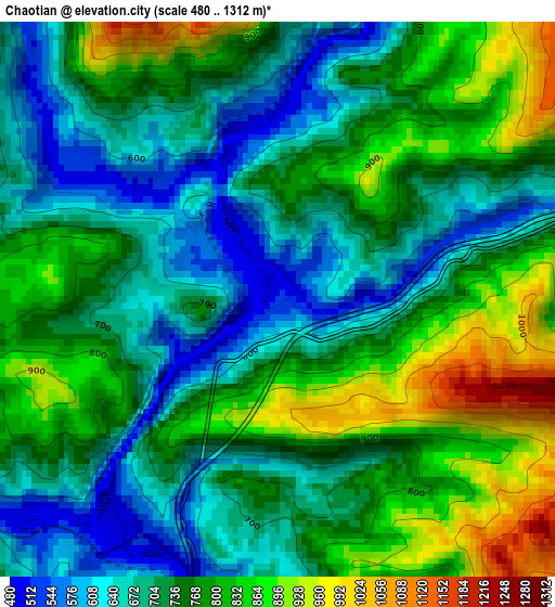
Below is the Elevation map of Chaotian, which displays elevation range with different colors. Scale of the first map is from 480 to 1312 m (1575 to 4304 ft) with average elevation of 747.2 meters (=2451 ft) [note 1]
These maps also provides idea of topography and contour of this city, they are displayed at different zoom levels. More info about maps, scale and edge coordinates you can find below images.
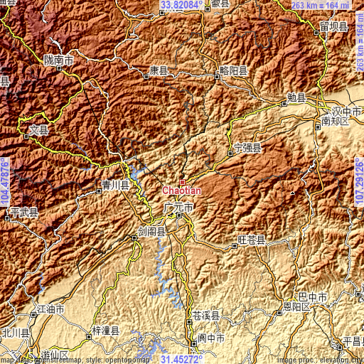
| \ | Map #1 | Topo.Map |
| Scale [m] | 480..1312 m | × |
| Scale [ft] | 1575..4304 ft | × |
| Average | 747.2 m = 2451 ft | × |
| Width | 8.23 km = 5.1 mi | 263.3 km = 163.6 mi |
| Height | 8.23 km = 5.1 mi | 263.3 km = 163.6 mi |
| ↑Max Latitude | 32.681616° | 33.82084° |
| Latitude at center | 32.64462° | 32.64462° |
| ↓Min Latitude | 32.607609° | 31.45272° |
| ← Min Longitude | 105.841065° | 104.47876° |
| Longitude center | 105.88501° | 105.88501° |
| →Max Longitude | 105.928955° | 107.29126° |
Nearby cities:
Cities around Chaotian sort by population:
• Guangyuan elevation 525 m
23.3 km,  194°
194°
• Dongxi 461 m
72.9 km,  152°
152°
• Puji 509 m
69.9 km,  130°
130°
• Changchi 732 m
90.1 km, 126°
• Zengjia 1397 m
20.4 km,  97°
97°
• Zuitai 1181 m
80.7 km,  341°
341°
• Lüeyang Chengguanzhen 745 m
80.5 km,  18°
18°
• Qiaozhuang 800 m
61.3 km,  264°
264°
• Donghe 483 m
60.1 km,  139°
139°
• Xiasi 578 m
52.6 km,  221°
221°
• Hanyuan 797 m
40.1 km,  58°
58°
• Yuanba 530 m
36.2 km,  168°
168°
Multilingual:
 En español:
Chaotian elevación 513 m.
 En France:
Chaotian élévation 513 m.
 Auf Deutsch:
Chaotian höhe über dem Meeresspiegel ist 513 m.

Sources and notes:
- [note 1] Map square and city borders are not equal. Map elevation data is calculated only from area inside that square.
- [src 1] Elevation data from geonames database provided with same terms of usage.
- [src 2] The elevation map of Chaotian is generated using elevation data from NASA's 3 arcsec (90m) resolution SRTM data.
- [src 3] Base (background) map © OpenStreetMap contributors tiles are generated by Geofabrik and OpenTopoMap.
Copyright & License:
This Chaotian Elevation Map is licensed under CC BY-SA. You may reuse any part from this page, if you give a proper credit by linking to this URL:
 More info on terms of use page.