Dongxi elevation
Dongxi (Sichuan), China elevation is 461 meters and Dongxi elevation in feet is 1512 ft above sea level [src 1]. Dongxi is a populated place (feature code) with elevation that is 97 meters (318 ft) smaller than average city elevation in China.
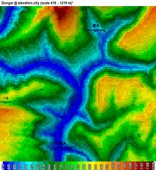
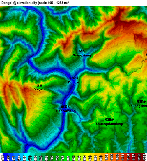
Below is the Elevation map of Dongxi, which displays elevation range with different colors. Scale of the first map is from 418 to 1219 m (1371 to 3999 ft) with average elevation of 710.9 meters (=2332 ft) [note 1]
These maps also provides idea of topography and contour of this city, they are displayed at different zoom levels. More info about maps, scale and edge coordinates you can find below images.
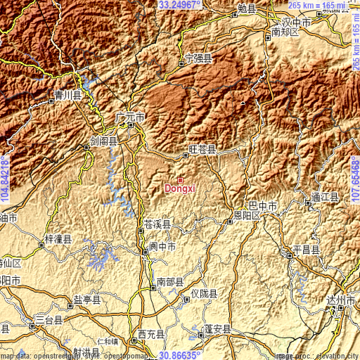
| \ | Map #1 | Map #2 | Topo.Map |
| Scale [m] | 418..1219 m | 405..1263 m | × |
| Scale [ft] | 1371..3999 ft | 1329..4144 ft | × |
| Average | 710.9 m = 2332 ft | 753.5 m = 2472 ft | × |
| Width | 8.28 km = 5.1 mi | 16.56 km = 10.3 mi | 265 km = 164.7 mi |
| Height | 8.28 km = 5.1 mi | 16.56 km = 10.3 mi | 265 km = 164.7 mi |
| ↑Max Latitude | 32.103003° | 32.140222° | 33.24967° |
| Latitude at center | 32.06577° | 32.06577° | 32.06577° |
| ↓Min Latitude | 32.028521° | 31.991258° | 30.86635° |
| ← Min Longitude | 106.204485° | 106.160539° | 104.84218° |
| Longitude center | 106.24843° | 106.24843° | 106.24843° |
| →Max Longitude | 106.292375° | 106.336321° | 107.65468° |
Nearby cities:
Cities around Dongxi sort by population:
• Guangyuan elevation 525 m
57.9 km,  316°
316°
• Langzhong 362 m
62.2 km,  202°
202°
• Puji 509 m
27.4 km,  45°
45°
• Changchi 732 m
40.1 km,  74°
74°
• Xialiang 550 m
49.3 km,  88°
88°
• Zengjia 1397 m
63.1 km,  347°
347°
• Nanjiang 577 m
63.6 km,  59°
59°
• Bazhou 366 m
54.6 km,  115°
115°
• Bazhong 455 m
51.6 km, 115°
• Lingjiang 389 m
47.4 km,  219°
219°
• Yuanba 530 m
39.5 km, 316°
• Donghe 483 m
19.3 km,  14°
14°
Multilingual:
 En español:
Dongxi elevación 461 m.
 En France:
Dongxi élévation 461 m.


Sources and notes:
- [note 1] Map square and city borders are not equal. Map elevation data is calculated only from area inside that square.
- [src 1] Elevation data from geonames database provided with same terms of usage.
- [src 2] The elevation map of Dongxi is generated using elevation data from NASA's 3 arcsec (90m) resolution SRTM data.
- [src 3] Base (background) map © OpenStreetMap contributors tiles are generated by Geofabrik and OpenTopoMap.
Copyright & License:
This Dongxi Elevation Map is licensed under CC BY-SA. You may reuse any part from this page, if you give a proper credit by linking to this URL:
 More info on terms of use page.