Zuitai elevation
Zuitai (Gansu), China elevation is 1181 meters and Zuitai elevation in feet is 3875 ft above sea level [src 1]. Zuitai is a seat of a third-order administrative division (feature code) with elevation that is 623 meters (2044 ft) bigger than average city elevation in China.
Below is the Elevation map of Zuitai, which displays elevation range with different colors. Scale of the first map is from 1131 to 2014 m (3711 to 6608 ft) with average elevation of 1429.3 meters (=4689 ft) [note 1]
These maps also provides idea of topography and contour of this city, they are displayed at different zoom levels. More info about maps, scale and edge coordinates you can find below images.
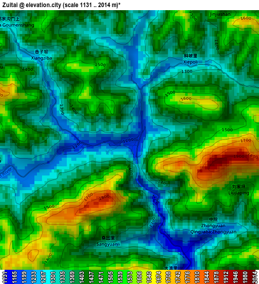
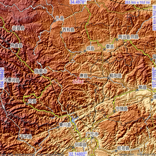
| \ | Map #1 | Topo.Map |
| Scale [m] | 1131..2014 m | × |
| Scale [ft] | 3711..6608 ft | × |
| Average | 1429.3 m = 4689 ft | × |
| Width | 8.16 km = 5.1 mi | 261.3 km = 162.4 mi |
| Height | 8.17 km = 5.1 mi | 261.3 km = 162.4 mi |
| ↑Max Latitude | 33.367539° | 34.4978° |
| Latitude at center | 33.33083° | 33.33083° |
| ↓Min Latitude | 33.294105° | 32.14802° |
| ← Min Longitude | 105.560725° | 104.19842° |
| Longitude center | 105.60467° | 105.60467° |
| →Max Longitude | 105.648615° | 107.01092° |
Nearby cities:
Cities around Zuitai sort by population:
• Guangyuan elevation 525 m
100.9 km,  168°
168°
• Zengjia 1397 m
91.6 km,  149°
149°
• Wenxian Chengguanzhen 1000 m
96 km,  243°
243°
• Liangdang Chengguanzhen 965 m
91.2 km,  45°
45°
• Qiaozhuang 800 m
89.3 km,  202°
202°
• Hanyuan 797 m
81.7 km,  132°
132°
• Hanyuan 1663 m
81 km,  339°
339°
• Chaotian 513 m
80.7 km,  161°
161°
• Huixian Chengguanzhen 911 m
65.7 km,  42°
42°
• Longnan 977 m
64.3 km,  276°
276°
• Lüeyang Chengguanzhen 745 m
51.1 km,  89°
89°
• Chengxian Chengguanzhen 993 m
47.9 km,  14°
14°
Multilingual:
 En español:
Zuitai elevación 1181 m.
 En France:
Zuitai élévation 1181 m.


Sources and notes:
- [note 1] Map square and city borders are not equal. Map elevation data is calculated only from area inside that square.
- [src 1] Elevation data from geonames database provided with same terms of usage.
- [src 2] The elevation map of Zuitai is generated using elevation data from NASA's 3 arcsec (90m) resolution SRTM data.
- [src 3] Base (background) map © OpenStreetMap contributors tiles are generated by Geofabrik and OpenTopoMap.
Copyright & License:
This Zuitai Elevation Map is licensed under CC BY-SA. You may reuse any part from this page, if you give a proper credit by linking to this URL:
 More info on terms of use page.