Hanyuan elevation
Hanyuan (Gansu), China elevation is 1663 meters and Hanyuan elevation in feet is 5456 ft above sea level [src 1]. Hanyuan is a seat of a third-order administrative division (feature code) with elevation that is 1105 meters (3625 ft) bigger than average city elevation in China.
Below is the Elevation map of Hanyuan, which displays elevation range with different colors. Scale of the first map is from 1559 to 1862 m (5115 to 6109 ft) with average elevation of 1688.5 meters (=5540 ft) [note 1]
These maps also provides idea of topography and contour of this city, they are displayed at different zoom levels. More info about maps, scale and edge coordinates you can find below images.
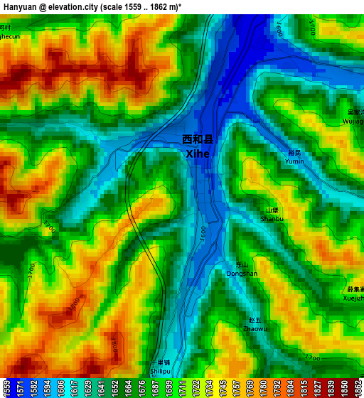
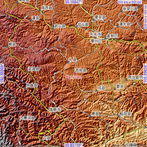
| \ | Map #1 | Topo.Map |
| Scale [m] | 1559..1862 m | × |
| Scale [ft] | 5115..6109 ft | × |
| Average | 1688.5 m = 5540 ft | × |
| Width | 8.1 km = 5 mi | 259.2 km = 161.1 mi |
| Height | 8.1 km = 5 mi | 259.2 km = 161.1 mi |
| ↑Max Latitude | 34.04725° | 35.16847° |
| Latitude at center | 34.01083° | 34.01083° |
| ↓Min Latitude | 33.974395° | 32.83719° |
| ← Min Longitude | 105.247995° | 103.88569° |
| Longitude center | 105.29194° | 105.29194° |
| →Max Longitude | 105.335885° | 106.69819° |
Nearby cities:
Cities around Hanyuan sort by population:
• Tianshui elevation 1153 m
75.6 km,  33°
33°
• Beidao 1087 m
83.1 km,  41°
41°
• Mawu 2058 m
57.8 km,  323°
323°
• Liangdang Chengguanzhen 965 m
93.8 km,  96°
96°
• Zhouqu Chengguanzhen 1326 m
89.4 km,  253°
253°
• Dangchang Chengguanzhen 1722 m
82.8 km,  272°
272°
• Zuitai 1181 m
81 km,  159°
159°
• Gangu Chengguanzhen 1287 m
80.7 km,  2°
2°
• Huixian Chengguanzhen 911 m
77.6 km,  110°
110°
• Longnan 977 m
76.5 km,  206°
206°
• Qincheng 1164 m
74.9 km, 32°
• Chengxian Chengguanzhen 993 m
50.1 km,  125°
125°
Multilingual:
 En español:
Hanyuan elevación 1663 m.
 En France:
Hanyuan élévation 1663 m.
 Auf Deutsch:
Hanyuan höhe über dem Meeresspiegel ist 1663 m.

Sources and notes:
- [note 1] Map square and city borders are not equal. Map elevation data is calculated only from area inside that square.
- [src 1] Elevation data from geonames database provided with same terms of usage.
- [src 2] The elevation map of Hanyuan is generated using elevation data from NASA's 3 arcsec (90m) resolution SRTM data.
- [src 3] Base (background) map © OpenStreetMap contributors tiles are generated by Geofabrik and OpenTopoMap.
Copyright & License:
This Hanyuan Elevation Map is licensed under CC BY-SA. You may reuse any part from this page, if you give a proper credit by linking to this URL:
 More info on terms of use page.