Jinchang elevation
Jinchang (Shanxi), China elevation is 752 meters and Jinchang elevation in feet is 2467 ft above sea level [src 1]. Jinchang is a seat of a third-order administrative division (feature code) with elevation that is 194 meters (636 ft) bigger than average city elevation in China.
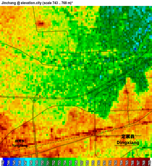
Below is the Elevation map of Jinchang, which displays elevation range with different colors. Scale of the first map is from 743 to 768 m (2438 to 2520 ft) with average elevation of 756.9 meters (=2483 ft) [note 1]
These maps also provides idea of topography and contour of this city, they are displayed at different zoom levels. More info about maps, scale and edge coordinates you can find below images.
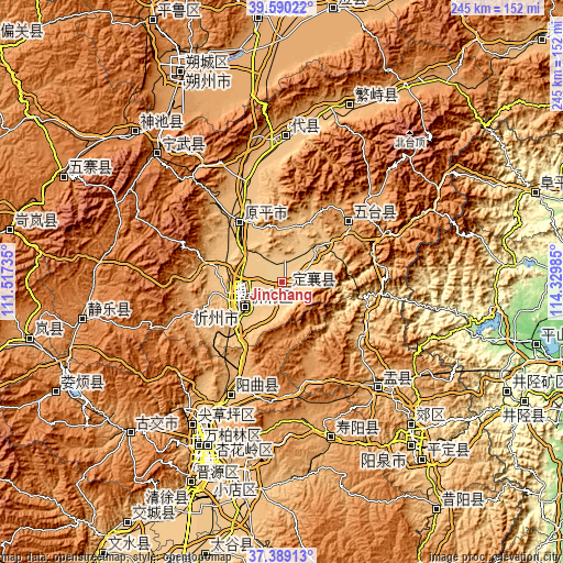
| \ | Map #1 | Topo.Map |
| Scale [m] | 743..768 m | × |
| Scale [ft] | 2438..2520 ft | × |
| Average | 756.9 m = 2483 ft | × |
| Width | 7.65 km = 4.8 mi | 244.7 km = 152 mi |
| Height | 7.65 km = 4.8 mi | 244.7 km = 152 mi |
| ↑Max Latitude | 38.532465° | 39.59022° |
| Latitude at center | 38.49808° | 38.49808° |
| ↓Min Latitude | 38.463679° | 37.38913° |
| ← Min Longitude | 112.879655° | 111.51735° |
| Longitude center | 112.9236° | 112.9236° |
| →Max Longitude | 112.967545° | 114.32985° |
Nearby cities:
Cities around Jinchang sort by population:
• Taiyuan elevation 795 m
76.8 km,  204°
204°
• Xinzhou 794 m
19.3 km,  239°
239°
• Yuanping 797 m
28.1 km,  329°
329°
• Fenghuang 1405 m
77.7 km,  315°
315°
• Liuxiang 799 m
76.6 km, 204°
• Chaicun 834 m
74 km,  211°
211°
• Julun 815 m
73 km, 205°
• Chaoyang 1062 m
68.5 km,  163°
163°
• Shangguan 878 m
63.5 km,  0°
0°
• Xiushui 946 m
59.7 km,  137°
137°
• Huangzhai 896 m
52.4 km, 206°
• Taicheng 1089 m
37 km,  45°
45°
Multilingual:
 En español:
Jinchang elevación 752 m.
 En France:
Jinchang élévation 752 m.
 Auf Deutsch:
Jinchang höhe über dem Meeresspiegel ist 752 m.

Sources and notes:
- [note 1] Map square and city borders are not equal. Map elevation data is calculated only from area inside that square.
- [src 1] Elevation data from geonames database provided with same terms of usage.
- [src 2] The elevation map of Jinchang is generated using elevation data from NASA's 3 arcsec (90m) resolution SRTM data.
- [src 3] Base (background) map © OpenStreetMap contributors tiles are generated by Geofabrik and OpenTopoMap.
Copyright & License:
This Jinchang Elevation Map is licensed under CC BY-SA. You may reuse any part from this page, if you give a proper credit by linking to this URL:
 More info on terms of use page.