Shangguan elevation
Shangguan (Shanxi), China elevation is 878 meters and Shangguan elevation in feet is 2881 ft above sea level [src 1]. Shangguan is a seat of a third-order administrative division (feature code) with elevation that is 320 meters (1050 ft) bigger than average city elevation in China.
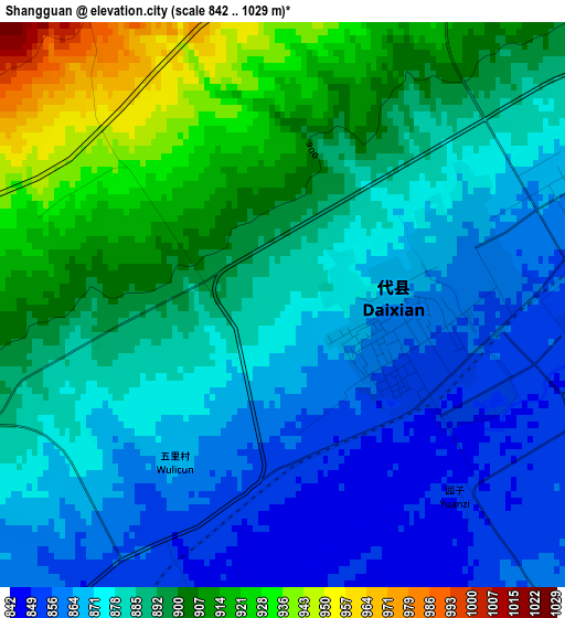
Below is the Elevation map of Shangguan, which displays elevation range with different colors. Scale of the first map is from 842 to 1029 m (2762 to 3376 ft) with average elevation of 885.3 meters (=2905 ft) [note 1]
These maps also provides idea of topography and contour of this city, they are displayed at different zoom levels. More info about maps, scale and edge coordinates you can find below images.
| \ | Map #1 | Topo.Map |
| Scale [m] | 842..1029 m | × |
| Scale [ft] | 2762..3376 ft | × |
| Average | 885.3 m = 2905 ft | × |
| Width | 7.59 km = 4.7 mi | 242.8 km = 150.9 mi |
| Height | 7.59 km = 4.7 mi | 242.8 km = 150.9 mi |
| ↑Max Latitude | 39.10312° | 40.15234° |
| Latitude at center | 39.06901° | 39.06901° |
| ↓Min Latitude | 39.034883° | 37.96879° |
| ← Min Longitude | 112.885185° | 111.52288° |
| Longitude center | 112.92913° | 112.92913° |
| →Max Longitude | 112.973075° | 114.33538° |
Nearby cities:
Cities around Shangguan sort by population:
• Xinzhou elevation 794 m
75.3 km,  193°
193°
• Yuanping 797 m
42 km,  200°
200°
• Yunzhong 1039 m
85.5 km,  9°
9°
• Jingping 1373 m
74.8 km,  312°
312°
• Longquan 1521 m
63.7 km,  271°
271°
• Jinchang 752 m
63.5 km,  180°
180°
• Yingxian 1006 m
58.8 km,  22°
22°
• Fenghuang 1405 m
55.1 km,  261°
261°
• Shuozhou 1098 m
51.6 km,  302°
302°
• Daiyue 1054 m
51.1 km,  349°
349°
• Taicheng 1089 m
45.6 km,  145°
145°
• Fanshi 925 m
31.9 km,  65°
65°
Multilingual:
 En español:
Shangguan elevación 878 m.
 En France:
Shangguan élévation 878 m.
 Auf Deutsch:
Shangguan höhe über dem Meeresspiegel ist 878 m.

Sources and notes:
- [note 1] Map square and city borders are not equal. Map elevation data is calculated only from area inside that square.
- [src 1] Elevation data from geonames database provided with same terms of usage.
- [src 2] The elevation map of Shangguan is generated using elevation data from NASA's 3 arcsec (90m) resolution SRTM data.
- [src 3] Base (background) map © OpenStreetMap contributors tiles are generated by Geofabrik and OpenTopoMap.
Copyright & License:
This Shangguan Elevation Map is licensed under CC BY-SA. You may reuse any part from this page, if you give a proper credit by linking to this URL:
 More info on terms of use page.