Taiyuan elevation
Taiyuan (Shanxi), China elevation is 795 meters and Taiyuan elevation in feet is 2608 ft above sea level [src 1]. Taiyuan is a seat of a first-order administrative division (feature code) with elevation that is 237 meters (778 ft) bigger than average city elevation in China.
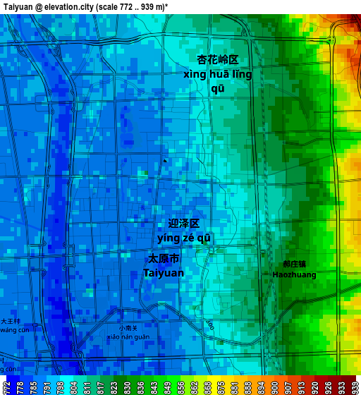
Below is the Elevation map of Taiyuan, which displays elevation range with different colors. Scale of the first map is from 772 to 939 m (2533 to 3081 ft) with average elevation of 807.3 meters (=2649 ft) [note 1]
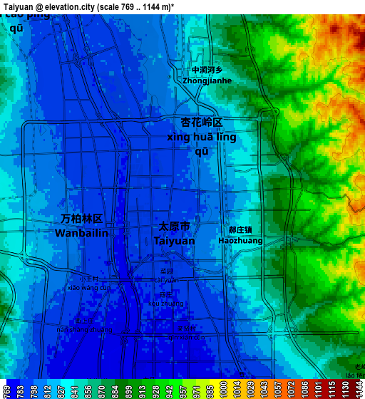
These maps also provides idea of topography and contour of this city, they are displayed at different zoom levels. More info about maps, scale and edge coordinates you can find below images.
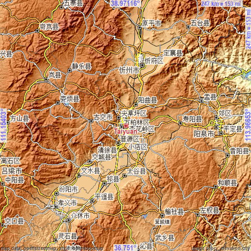
| \ | Map #1 | Map #2 | Topo.Map |
| Scale [m] | 772..939 m | 769..1144 m | × |
| Scale [ft] | 2533..3081 ft | 2523..3753 ft | × |
| Average | 807.3 m = 2649 ft | 841.7 m = 2761 ft | × |
| Width | 7.71 km = 4.8 mi | 15.43 km = 9.6 mi | 246.9 km = 153.4 mi |
| Height | 7.71 km = 4.8 mi | 15.43 km = 9.6 mi | 246.9 km = 153.4 mi |
| ↑Max Latitude | 37.904123° | 37.938789° | 38.97116° |
| Latitude at center | 37.86944° | 37.86944° | 37.86944° |
| ↓Min Latitude | 37.834741° | 37.800025° | 36.751° |
| ← Min Longitude | 112.516335° | 112.472389° | 111.15403° |
| Longitude center | 112.56028° | 112.56028° | 112.56028° |
| →Max Longitude | 112.604225° | 112.648171° | 113.96653° |
Nearby cities:
Cities around Taiyuan sort by population:
• Yuci elevation 798 m
25.9 km,  144°
144°
• Tianning 762 m
50.2 km,  224°
224°
• Mingxing 788 m
49.3 km,  181°
181°
• Qingyuan 784 m
34.8 km, 216°
• Dongqu 971 m
32.1 km,  280°
280°
• Huangzhai 896 m
24.5 km,  20°
20°
• Jinyuan 779 m
17.7 km,  206°
206°
• Xiaodian 775 m
14.8 km, 181°
• Chaicun 834 m
10.2 km,  313°
313°
• Julun 815 m
4.2 km,  356°
356°
• Qianfeng 789 m
4.1 km,  237°
237°
• Liuxiang 799 m
0.2 km,  5°
5°
Multilingual:
 En español:
Taiyuan elevación 795 m.
 En France:
Taiyuan élévation 795 m.


Sources and notes:
- [note 1] Map square and city borders are not equal. Map elevation data is calculated only from area inside that square.
- [src 1] Elevation data from geonames database provided with same terms of usage.
- [src 2] The elevation map of Taiyuan is generated using elevation data from NASA's 3 arcsec (90m) resolution SRTM data.
- [src 3] Base (background) map © OpenStreetMap contributors tiles are generated by Geofabrik and OpenTopoMap.
Copyright & License:
This Taiyuan Elevation Map is licensed under CC BY-SA. You may reuse any part from this page, if you give a proper credit by linking to this URL:
 More info on terms of use page.