Donglan elevation
Donglan (Guangxi), China elevation is 330 meters and Donglan elevation in feet is 1083 ft above sea level [src 1]. Donglan is a seat of a third-order administrative division (feature code) with elevation that is 228 meters (748 ft) smaller than average city elevation in China.
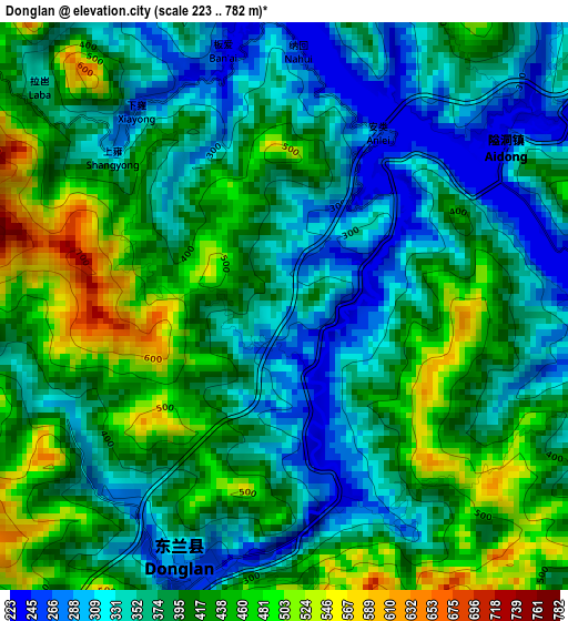
Below is the Elevation map of Donglan, which displays elevation range with different colors. Scale of the first map is from 223 to 782 m (732 to 2566 ft) with average elevation of 389.6 meters (=1278 ft) [note 1]
These maps also provides idea of topography and contour of this city, they are displayed at different zoom levels. More info about maps, scale and edge coordinates you can find below images.
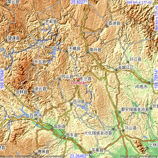
| \ | Map #1 | Topo.Map |
| Scale [m] | 223..782 m | × |
| Scale [ft] | 732..2566 ft | × |
| Average | 389.6 m = 1278 ft | × |
| Width | 8.89 km = 5.5 mi | 284.4 km = 176.7 mi |
| Height | 8.89 km = 5.5 mi | 284.4 km = 176.7 mi |
| ↑Max Latitude | 24.590146° | 25.8227° |
| Latitude at center | 24.55018° | 24.55018° |
| ↓Min Latitude | 24.510201° | 23.26462° |
| ← Min Longitude | 107.338945° | 105.97664° |
| Longitude center | 107.38289° | 107.38289° |
| →Max Longitude | 107.426835° | 108.78914° |
Nearby cities:
Cities around Donglan sort by population:
• Baise City elevation 136 m
106.4 km,  227°
227°
• Dahua 230 m
106.2 km,  144°
144°
• Pingma 111 m
105.4 km,  195°
195°
• Anyang 158 m
99.4 km,  133°
133°
• Tianzhou 119 m
98.9 km,  209°
209°
• Si’en 233 m
95.5 km,  70°
70°
• Tongle 1169 m
87.9 km,  292°
292°
• Sicheng 1047 m
82.7 km,  258°
258°
• Liupai 697 m
58.4 km,  338°
338°
• Nandan Chengguanzhen 682 m
54.1 km,  18°
18°
• Bama 266 m
44.3 km, 197°
• Fengcheng 554 m
34.5 km,  273°
273°
Multilingual:
 En español:
Donglan elevación 330 m.
 En France:
Donglan élévation 330 m.


Sources and notes:
- [note 1] Map square and city borders are not equal. Map elevation data is calculated only from area inside that square.
- [src 1] Elevation data from geonames database provided with same terms of usage.
- [src 2] The elevation map of Donglan is generated using elevation data from NASA's 3 arcsec (90m) resolution SRTM data.
- [src 3] Base (background) map © OpenStreetMap contributors tiles are generated by Geofabrik and OpenTopoMap.
Copyright & License:
This Donglan Elevation Map is licensed under CC BY-SA. You may reuse any part from this page, if you give a proper credit by linking to this URL:
 More info on terms of use page.