Si’en elevation
Si’en (Guangxi), China elevation is 233 meters and Si’en elevation in feet is 764 ft above sea level [src 1]. Si’en is a seat of a third-order administrative division (feature code) with elevation that is 325 meters (1066 ft) smaller than average city elevation in China.
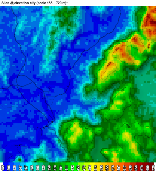
Below is the Elevation map of Si’en, which displays elevation range with different colors. Scale of the first map is from 185 to 720 m (607 to 2362 ft) with average elevation of 301 meters (=988 ft) [note 1]
These maps also provides idea of topography and contour of this city, they are displayed at different zoom levels. More info about maps, scale and edge coordinates you can find below images.
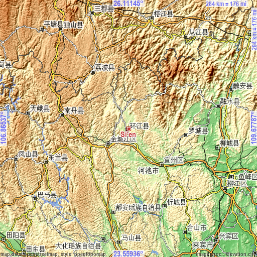
| \ | Map #1 | Topo.Map |
| Scale [m] | 185..720 m | × |
| Scale [ft] | 607..2362 ft | × |
| Average | 301 m = 988 ft | × |
| Width | 8.87 km = 5.5 mi | 283.8 km = 176.3 mi |
| Height | 8.87 km = 5.5 mi | 283.8 km = 176.3 mi |
| ↑Max Latitude | 24.881853° | 26.11145° |
| Latitude at center | 24.84198° | 24.84198° |
| ↓Min Latitude | 24.802095° | 23.55936° |
| ← Min Longitude | 108.227675° | 106.86537° |
| Longitude center | 108.27162° | 108.27162° |
| →Max Longitude | 108.315565° | 109.67787° |
Nearby cities:
Cities around Si’en sort by population:
• Tingdong elevation 322 m
114.5 km,  17°
17°
• Gaowu 787 m
102.6 km,  38°
38°
• Xiajiang 222 m
110 km, 22°
• Pingjiang 275 m
114.7 km, 20°
• Liupai 697 m
112.9 km,  281°
281°
• Anyang 158 m
102 km,  189°
189°
• Rongshui 114 m
101.7 km,  75°
75°
• Dabu 100 m
99.2 km,  101°
101°
• Donglan 330 m
95.5 km,  250°
250°
• Xincheng Chengguanzhen 150 m
92.5 km,  155°
155°
• Nandan Chengguanzhen 682 m
74.4 km, 284°
• Dongmen 348 m
63.7 km, 95°
Multilingual:
 En español:
Si’en elevación 233 m.
 En France:
Si’en élévation 233 m.


Sources and notes:
- [note 1] Map square and city borders are not equal. Map elevation data is calculated only from area inside that square.
- [src 1] Elevation data from geonames database provided with same terms of usage.
- [src 2] The elevation map of Si’en is generated using elevation data from NASA's 3 arcsec (90m) resolution SRTM data.
- [src 3] Base (background) map © OpenStreetMap contributors tiles are generated by Geofabrik and OpenTopoMap.
Copyright & License:
This Si’en Elevation Map is licensed under CC BY-SA. You may reuse any part from this page, if you give a proper credit by linking to this URL:
 More info on terms of use page.