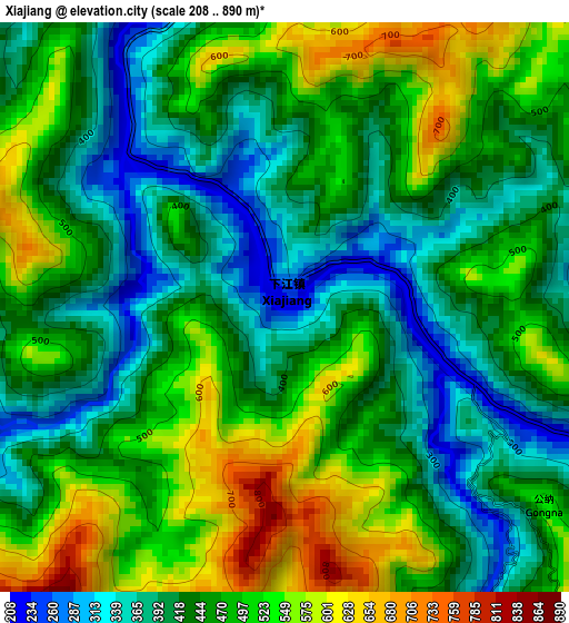
Xiajiang elevation
Xiajiang (Guizhou), China elevation is 222 meters and Xiajiang elevation in feet is 728 ft above sea level [src 1]. Xiajiang is a populated place (feature code) with elevation that is 336 meters (1102 ft) smaller than average city elevation in China.
Below is the Elevation map of Xiajiang, which displays elevation range with different colors. Scale of the first map is from 208 to 890 m (682 to 2920 ft) with average elevation of 458.7 meters (=1505 ft) [note 1]
These maps also provides idea of topography and contour of this city, they are displayed at different zoom levels. More info about maps, scale and edge coordinates you can find below images.
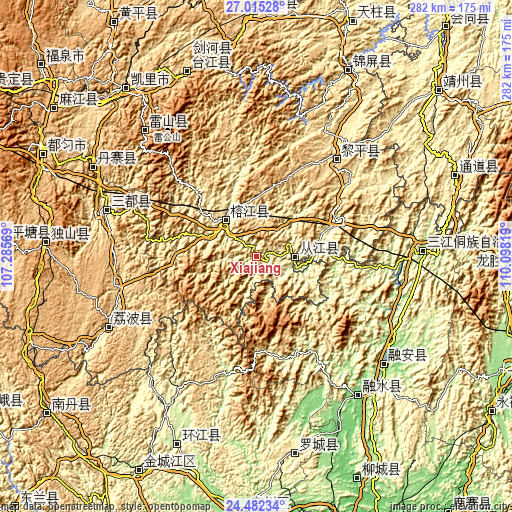
| \ | Map #1 | Topo.Map |
| Scale [m] | 208..890 m | × |
| Scale [ft] | 682..2920 ft | × |
| Average | 458.7 m = 1505 ft | × |
| Width | 8.8 km = 5.5 mi | 281.6 km = 175 mi |
| Height | 8.8 km = 5.5 mi | 281.6 km = 175 mi |
| ↑Max Latitude | 25.795133° | 27.01528° |
| Latitude at center | 25.75556° | 25.75556° |
| ↓Min Latitude | 25.715974° | 24.48234° |
| ← Min Longitude | 108.647995° | 107.28569° |
| Longitude center | 108.69194° | 108.69194° |
| →Max Longitude | 108.735885° | 110.09819° |
Nearby cities:
Cities around Xiajiang sort by population:
• Longlisuo elevation 456 m
83.9 km,  29°
29°
• Zhongchao 461 m
67.8 km,  51°
51°
• Aoshi 453 m
81.2 km, 27°
• Dundong 499 m
53.2 km,  57°
57°
• Gaozeng 254 m
25.1 km,  78°
78°
• Tingdong 322 m
11 km,  313°
313°
• Xishan 229 m
28.3 km,  106°
106°
• Gaowu 787 m
30.5 km,  134°
134°
• Darong 215 m
17.5 km, 79°
• Hongzhou 378 m
82.7 km, 60°
• Pingjiang 329 m
38.1 km, 308°
• Pingjiang 275 m
6.9 km,  334°
334°
Multilingual:
 En español:
Xiajiang elevación 222 m.
 En France:
Xiajiang élévation 222 m.
 Auf Deutsch:
Xiajiang höhe über dem Meeresspiegel ist 222 m.

Sources and notes:
- [note 1] Map square and city borders are not equal. Map elevation data is calculated only from area inside that square.
- [src 1] Elevation data from geonames database provided with same terms of usage.
- [src 2] The elevation map of Xiajiang is generated using elevation data from NASA's 3 arcsec (90m) resolution SRTM data.
- [src 3] Base (background) map © OpenStreetMap contributors tiles are generated by Geofabrik and OpenTopoMap.
Copyright & License:
This Xiajiang Elevation Map is licensed under CC BY-SA. You may reuse any part from this page, if you give a proper credit by linking to this URL:
 More info on terms of use page.