Baise City elevation
Baise City (Guangxi), China elevation is 136 meters and Baise City elevation in feet is 446 ft above sea level [src 1]. Baise City is a seat of a second-order administrative division (feature code) with elevation that is 422 meters (1385 ft) smaller than average city elevation in China.
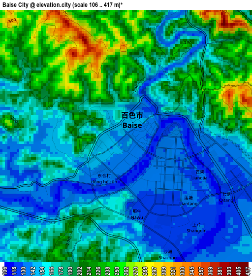
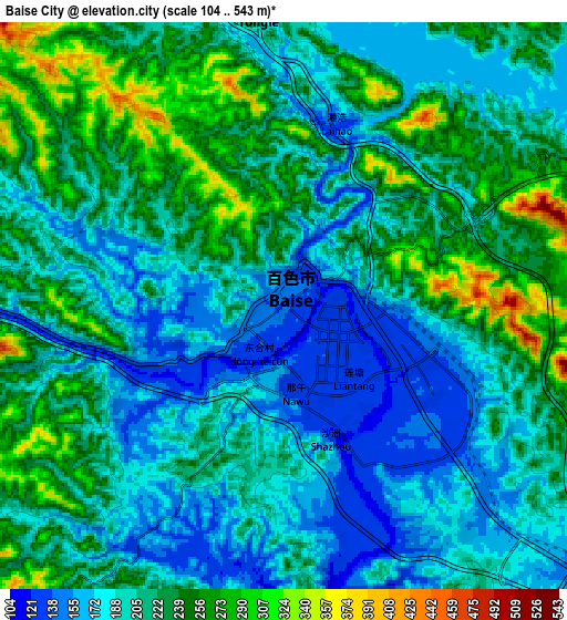
Below is the Elevation map of Baise City, which displays elevation range with different colors. Scale of the first map is from 106 to 417 m (348 to 1368 ft) with average elevation of 181 meters (=594 ft) [note 1]
These maps also provides idea of topography and contour of this city, they are displayed at different zoom levels. More info about maps, scale and edge coordinates you can find below images.
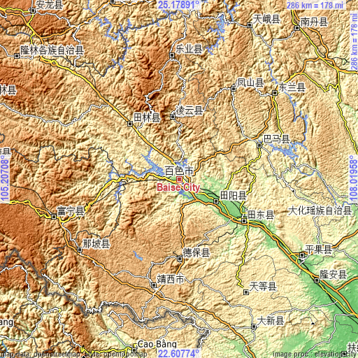
| \ | Map #1 | Map #2 | Topo.Map |
| Scale [m] | 106..417 m | 104..543 m | × |
| Scale [ft] | 348..1368 ft | 341..1781 ft | × |
| Average | 181 m = 594 ft | 212 m = 696 ft | × |
| Width | 8.93 km = 5.5 mi | 17.87 km = 11.1 mi | 285.9 km = 177.6 mi |
| Height | 8.93 km = 5.5 mi | 17.87 km = 11.1 mi | 285.9 km = 177.6 mi |
| ↑Max Latitude | 23.939891° | 23.98005° | 25.17891° |
| Latitude at center | 23.89972° | 23.89972° | 23.89972° |
| ↓Min Latitude | 23.859536° | 23.819341° | 22.60774° |
| ← Min Longitude | 106.569385° | 106.525439° | 105.20708° |
| Longitude center | 106.61333° | 106.61333° | 106.61333° |
| →Max Longitude | 106.657275° | 106.701221° | 108.01958° |
Nearby cities:
Cities around Baise City sort by population:
• Tongle elevation 1169 m
105.5 km,  357°
357°
• Xinhua 975 m
101.8 km,  253°
253°
• Tiandeng 458 m
98.9 km,  150°
150°
• Napo Chengxiangzhen 1017 m
95.8 km,  240°
240°
• Fengcheng 554 m
86.4 km,  30°
30°
• Xinjing 923 m
81 km,  196°
196°
• Bama 266 m
71.2 km,  64°
64°
• Leli 583 m
62.9 km,  323°
323°
• Pingma 111 m
57.6 km,  120°
120°
• Debao Chengguanzhen 688 m
57.4 km,  184°
184°
• Sicheng 1047 m
56.3 km, 356°
• Tianzhou 119 m
31.9 km, 115°
Multilingual:
 En español:
Baise City elevación 136 m.
 En France:
Baise City élévation 136 m.
 Auf Deutsch:
Baise City höhe über dem Meeresspiegel ist 136 m.

Sources and notes:
- [note 1] Map square and city borders are not equal. Map elevation data is calculated only from area inside that square.
- [src 1] Elevation data from geonames database provided with same terms of usage.
- [src 2] The elevation map of Baise City is generated using elevation data from NASA's 3 arcsec (90m) resolution SRTM data.
- [src 3] Base (background) map © OpenStreetMap contributors tiles are generated by Geofabrik and OpenTopoMap.
Copyright & License:
This Baise City Elevation Map is licensed under CC BY-SA. You may reuse any part from this page, if you give a proper credit by linking to this URL:
 More info on terms of use page.