Napo Chengxiangzhen elevation
Napo Chengxiangzhen (Guangxi), China elevation is 1017 meters and Napo Chengxiangzhen elevation in feet is 3337 ft above sea level [src 1]. Napo Chengxiangzhen is a seat of a third-order administrative division (feature code) with elevation that is 459 meters (1506 ft) bigger than average city elevation in China.
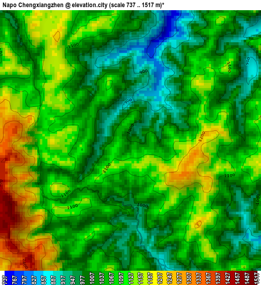
Below is the Elevation map of Napo Chengxiangzhen, which displays elevation range with different colors. Scale of the first map is from 737 to 1517 m (2418 to 4977 ft) with average elevation of 1065.5 meters (=3496 ft) [note 1]
These maps also provides idea of topography and contour of this city, they are displayed at different zoom levels. More info about maps, scale and edge coordinates you can find below images.
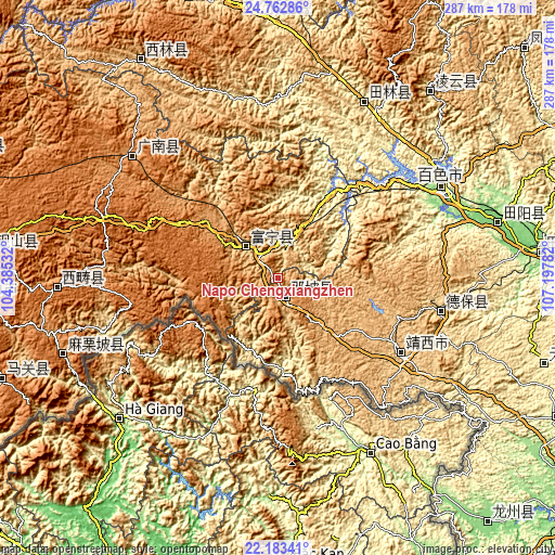
| \ | Map #1 | Topo.Map |
| Scale [m] | 737..1517 m | × |
| Scale [ft] | 2418..4977 ft | × |
| Average | 1065.5 m = 3496 ft | × |
| Width | 8.96 km = 5.6 mi | 286.8 km = 178.2 mi |
| Height | 8.96 km = 5.6 mi | 286.8 km = 178.2 mi |
| ↑Max Latitude | 23.519741° | 24.76286° |
| Latitude at center | 23.47944° | 23.47944° |
| ↓Min Latitude | 23.439127° | 22.18341° |
| ← Min Longitude | 105.747625° | 104.38532° |
| Longitude center | 105.79157° | 105.79157° |
| →Max Longitude | 105.835515° | 107.19782° |
Nearby cities:
Cities around Napo Chengxiangzhen sort by population:
• Baise City elevation 136 m
95.8 km,  60°
60°
• Tiandeng 458 m
138.6 km,  106°
106°
• Pingma 111 m
134.7 km,  82°
82°
• Sicheng 1047 m
130.6 km,  37°
37°
• Tianzhou 119 m
117.4 km,  73°
73°
• Mali 1239 m
114.3 km,  249°
249°
• Xisa 1515 m
110.6 km,  268°
268°
• Leli 583 m
107.6 km,  25°
25°
• Liancheng 1245 m
96.8 km,  311°
311°
• Debao Chengguanzhen 688 m
80.5 km,  97°
97°
• Xinjing 923 m
67.7 km,  117°
117°
• Xinhua 975 m
23 km,  322°
322°
Multilingual:
 En español:
Napo Chengxiangzhen elevación 1017 m.
 En France:
Napo Chengxiangzhen élévation 1017 m.
 Auf Deutsch:
Napo Chengxiangzhen höhe über dem Meeresspiegel ist 1017 m.
 На русском:
Napo Chengxiangzhen высота над уровнем моря 1017 м
Sources and notes:
- [note 1] Map square and city borders are not equal. Map elevation data is calculated only from area inside that square.
- [src 1] Elevation data from geonames database provided with same terms of usage.
- [src 2] The elevation map of Napo Chengxiangzhen is generated using elevation data from NASA's 3 arcsec (90m) resolution SRTM data.
- [src 3] Base (background) map © OpenStreetMap contributors tiles are generated by Geofabrik and OpenTopoMap.
Copyright & License:
This Napo Chengxiangzhen Elevation Map is licensed under CC BY-SA. You may reuse any part from this page, if you give a proper credit by linking to this URL:
 More info on terms of use page.