Xinyi elevation
Xinyi (Guangdong), China elevation is 89 meters and Xinyi elevation in feet is 292 ft above sea level [src 1]. Xinyi is a populated place (feature code) with elevation that is 469 meters (1539 ft) smaller than average city elevation in China.
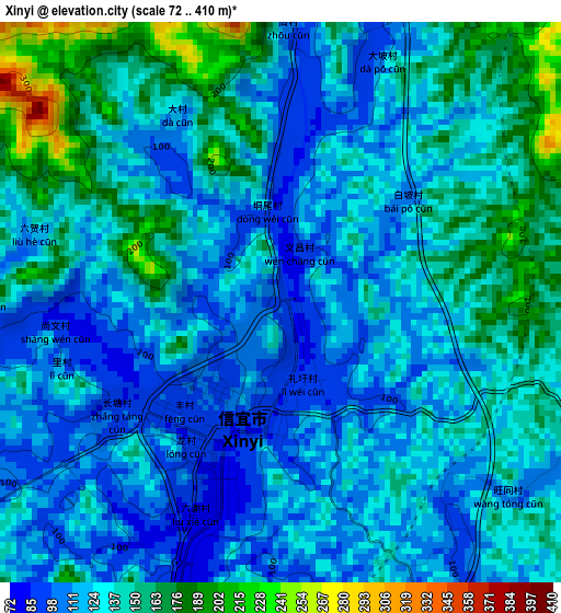
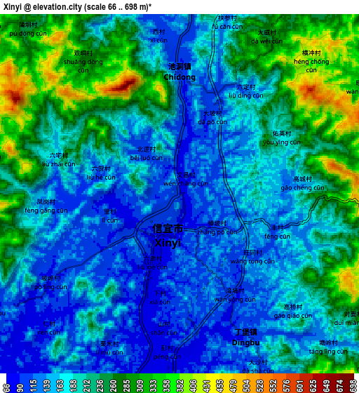
Below is the Elevation map of Xinyi, which displays elevation range with different colors. Scale of the first map is from 72 to 410 m (236 to 1345 ft) with average elevation of 131.6 meters (=432 ft) [note 1]
These maps also provides idea of topography and contour of this city, they are displayed at different zoom levels. More info about maps, scale and edge coordinates you can find below images.
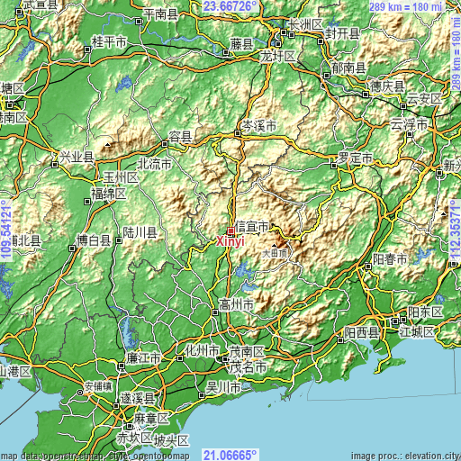
| \ | Map #1 | Map #2 | Topo.Map |
| Scale [m] | 72..410 m | 66..698 m | × |
| Scale [ft] | 236..1345 ft | 217..2290 ft | × |
| Average | 131.6 m = 432 ft | 200 m = 656 ft | × |
| Width | 9.04 km = 5.6 mi | 18.07 km = 11.2 mi | 289.2 km = 179.7 mi |
| Height | 9.04 km = 5.6 mi | 18.07 km = 11.2 mi | 289.2 km = 179.7 mi |
| ↑Max Latitude | 22.413661° | 22.454281° | 23.66726° |
| Latitude at center | 22.37303° | 22.37303° | 22.37303° |
| ↓Min Latitude | 22.332387° | 22.291732° | 21.06665° |
| ← Min Longitude | 110.903515° | 110.859569° | 109.54121° |
| Longitude center | 110.94746° | 110.94746° | 110.94746° |
| →Max Longitude | 110.991405° | 111.035351° | 112.35371° |
Nearby cities:
Cities around Xinyi sort by population:
• Gaozhou elevation 57 m
49.4 km,  192°
192°
• Yangchun 22 m
89 km,  104°
104°
• Yulin 83 m
86.9 km,  289°
289°
• Huazhou 35 m
90.4 km,  204°
204°
• Nandu 88 m
54.8 km,  346°
346°
• Lingcheng 102 m
71.8 km,  301°
301°
• Hexi 22 m
82.9 km, 202°
• Maoming 25 m
80.5 km,  183°
183°
• Luocheng 50 m
77.5 km,  55°
55°
• Wenquan 99 m
71.4 km,  265°
265°
• Rongcheng 95 m
67.9 km,  322°
322°
• Dongzhen 90 m
1.2 km,  309°
309°
Multilingual:
 En español:
Xinyi elevación 89 m.
 En France:
Xinyi élévation 89 m.


Sources and notes:
- [note 1] Map square and city borders are not equal. Map elevation data is calculated only from area inside that square.
- [src 1] Elevation data from geonames database provided with same terms of usage.
- [src 2] The elevation map of Xinyi is generated using elevation data from NASA's 3 arcsec (90m) resolution SRTM data.
- [src 3] Base (background) map © OpenStreetMap contributors tiles are generated by Geofabrik and OpenTopoMap.
Copyright & License:
This Xinyi Elevation Map is licensed under CC BY-SA. You may reuse any part from this page, if you give a proper credit by linking to this URL:
 More info on terms of use page.