Lingcheng elevation
Lingcheng (Guangxi), China elevation is 102 meters and Lingcheng elevation in feet is 335 ft above sea level [src 1]. Lingcheng is a populated place (feature code) with elevation that is 456 meters (1496 ft) smaller than average city elevation in China.
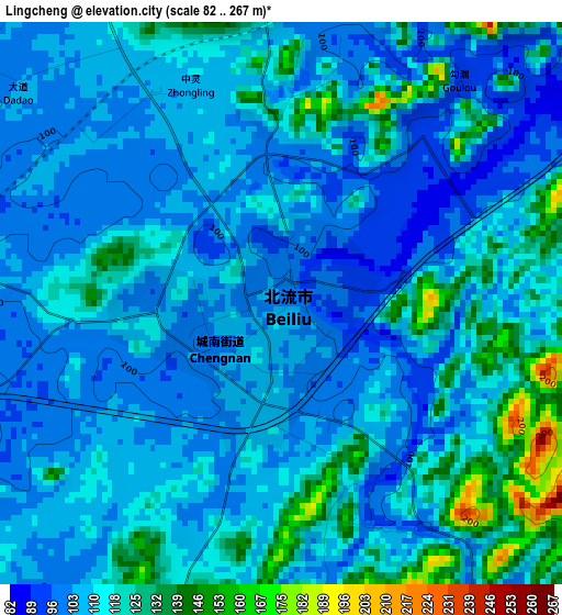
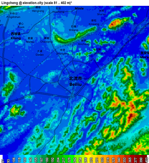
Below is the Elevation map of Lingcheng, which displays elevation range with different colors. Scale of the first map is from 82 to 267 m (269 to 876 ft) with average elevation of 112.4 meters (=369 ft) [note 1]
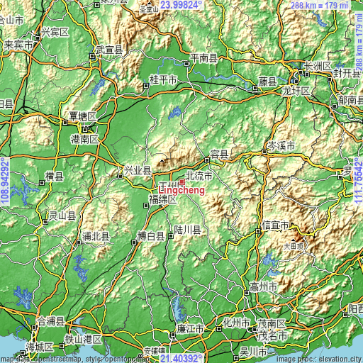
These maps also provides idea of topography and contour of this city, they are displayed at different zoom levels. More info about maps, scale and edge coordinates you can find below images.
| \ | Map #1 | Map #2 | Topo.Map |
| Scale [m] | 82..267 m | 81..402 m | × |
| Scale [ft] | 269..876 ft | 266..1319 ft | × |
| Average | 112.4 m = 369 ft | 129.4 m = 425 ft | × |
| Width | 9.01 km = 5.6 mi | 18.03 km = 11.2 mi | 288.5 km = 179.3 mi |
| Height | 9.02 km = 5.6 mi | 18.03 km = 11.2 mi | 288.5 km = 179.3 mi |
| ↑Max Latitude | 22.747753° | 22.788274° | 23.99824° |
| Latitude at center | 22.70722° | 22.70722° | 22.70722° |
| ↓Min Latitude | 22.666675° | 22.626118° | 21.40392° |
| ← Min Longitude | 110.305225° | 110.261279° | 108.94292° |
| Longitude center | 110.34917° | 110.34917° | 110.34917° |
| →Max Longitude | 110.393115° | 110.437061° | 111.75542° |
Nearby cities:
Cities around Lingcheng sort by population:
• Yulin elevation 83 m
22 km,  248°
248°
• Xinyi 89 m
71.8 km,  121°
121°
• Guiping 44 m
81.3 km,  339°
339°
• Nandu 88 m
51.2 km,  71°
71°
• Jinji 42 m
75.7 km,  40°
40°
• Yashan 64 m
70.5 km,  216°
216°
• Dongzhen 90 m
70.7 km, 121°
• Qiaoxu 49 m
66.4 km,  294°
294°
• Bobai 62 m
61.9 km, 218°
• Shinan 123 m
48.9 km,  274°
274°
• Wenquan 99 m
43.5 km,  192°
192°
• Rongcheng 95 m
26.3 km,  50°
50°
Multilingual:
 En español:
Lingcheng elevación 102 m.
 En France:
Lingcheng élévation 102 m.
 Auf Deutsch:
Lingcheng höhe über dem Meeresspiegel ist 102 m.

Sources and notes:
- [note 1] Map square and city borders are not equal. Map elevation data is calculated only from area inside that square.
- [src 1] Elevation data from geonames database provided with same terms of usage.
- [src 2] The elevation map of Lingcheng is generated using elevation data from NASA's 3 arcsec (90m) resolution SRTM data.
- [src 3] Base (background) map © OpenStreetMap contributors tiles are generated by Geofabrik and OpenTopoMap.
Copyright & License:
This Lingcheng Elevation Map is licensed under CC BY-SA. You may reuse any part from this page, if you give a proper credit by linking to this URL:
 More info on terms of use page.