Jinji elevation
Jinji (Guangxi), China elevation is 42 meters and Jinji elevation in feet is 138 ft above sea level [src 1]. Jinji is a populated place (feature code) with elevation that is 516 meters (1693 ft) smaller than average city elevation in China.
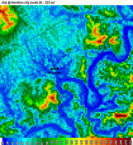
Below is the Elevation map of Jinji, which displays elevation range with different colors. Scale of the first map is from 26 to 223 m (85 to 732 ft) with average elevation of 69.1 meters (=227 ft) [note 1]
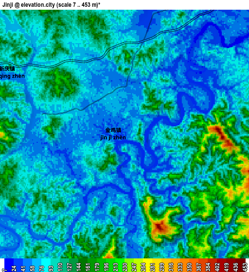
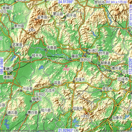
These maps also provides idea of topography and contour of this city, they are displayed at different zoom levels. More info about maps, scale and edge coordinates you can find below images.
| \ | Map #1 | Map #2 | Topo.Map |
| Scale [m] | 26..223 m | 7..453 m | × |
| Scale [ft] | 85..732 ft | 23..1486 ft | × |
| Average | 69.1 m = 227 ft | 95.6 m = 314 ft | × |
| Width | 8.98 km = 5.6 mi | 17.96 km = 11.2 mi | 287.4 km = 178.6 mi |
| Height | 8.98 km = 5.6 mi | 17.96 km = 11.2 mi | 287.4 km = 178.6 mi |
| ↑Max Latitude | 23.268437° | 23.308802° | 24.51398° |
| Latitude at center | 23.22806° | 23.22806° | 23.22806° |
| ↓Min Latitude | 23.187671° | 23.147269° | 21.92963° |
| ← Min Longitude | 110.782165° | 110.738219° | 109.41986° |
| Longitude center | 110.82611° | 110.82611° | 110.82611° |
| →Max Longitude | 110.870055° | 110.914001° | 112.23236° |
Nearby cities:
Cities around Jinji sort by population:
• Wuzhou elevation 75 m
57.6 km,  60°
60°
• Ducheng 23 m
71.8 km,  88°
88°
• Guiping 44 m
78.9 km,  283°
283°
• Pingnan 39 m
56.6 km,  308°
308°
• Nandu 88 m
41.8 km,  180°
180°
• Lingcheng 102 m
75.7 km,  220°
220°
• Dongzhen 90 m
95 km,  173°
173°
• Luocheng 50 m
91.5 km,  123°
123°
• Jiangkou 35 m
72.4 km,  71°
71°
• Rongcheng 95 m
50.1 km,  214°
214°
• Longxu 50 m
46.6 km, 63°
• Tengzhou 40 m
19 km,  20°
20°
Multilingual:
 En español:
Jinji elevación 42 m.
 En France:
Jinji élévation 42 m.


Sources and notes:
- [note 1] Map square and city borders are not equal. Map elevation data is calculated only from area inside that square.
- [src 1] Elevation data from geonames database provided with same terms of usage.
- [src 2] The elevation map of Jinji is generated using elevation data from NASA's 3 arcsec (90m) resolution SRTM data.
- [src 3] Base (background) map © OpenStreetMap contributors tiles are generated by Geofabrik and OpenTopoMap.
Copyright & License:
This Jinji Elevation Map is licensed under CC BY-SA. You may reuse any part from this page, if you give a proper credit by linking to this URL:
 More info on terms of use page.