Handan elevation
Handan (Hebei), China elevation is 66 meters and Handan elevation in feet is 217 ft above sea level [src 1]. Handan is a populated place (feature code) with elevation that is 492 meters (1614 ft) smaller than average city elevation in China.
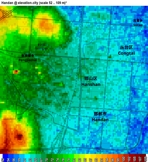
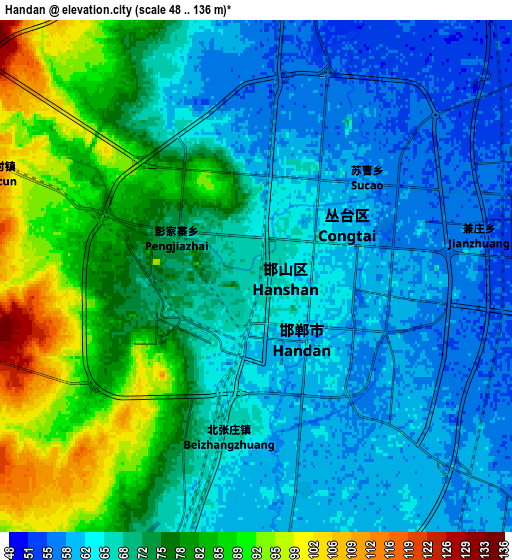
Below is the Elevation map of Handan, which displays elevation range with different colors. Scale of the first map is from 52 to 109 m (171 to 358 ft) with average elevation of 67.7 meters (=222 ft) [note 1]
These maps also provides idea of topography and contour of this city, they are displayed at different zoom levels. More info about maps, scale and edge coordinates you can find below images.
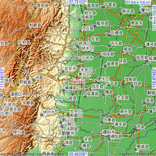
| \ | Map #1 | Map #2 | Topo.Map |
| Scale [m] | 52..109 m | 48..136 m | × |
| Scale [ft] | 171..358 ft | 157..446 ft | × |
| Average | 67.7 m = 222 ft | 71.1 m = 233 ft | × |
| Width | 7.85 km = 4.9 mi | 15.69 km = 9.7 mi | 251 km = 156 mi |
| Height | 7.85 km = 4.9 mi | 15.69 km = 9.7 mi | 251 km = 156 mi |
| ↑Max Latitude | 36.635832° | 36.671087° | 37.72122° |
| Latitude at center | 36.60056° | 36.60056° | 36.60056° |
| ↓Min Latitude | 36.565272° | 36.529968° | 35.46338° |
| ← Min Longitude | 114.423835° | 114.379889° | 113.06153° |
| Longitude center | 114.46778° | 114.46778° | 114.46778° |
| →Max Longitude | 114.511725° | 114.555671° | 115.87403° |
Nearby cities:
Cities around Handan sort by population:
• Anyang elevation 70 m
56.6 km,  187°
187°
• Xingtai 76 m
51.5 km,  2°
2°
• Hebi 138 m
81.8 km,  197°
197°
• Shahecheng 73 m
37.7 km,  5°
5°
• Linshui 138 m
30.6 km,  230°
230°
• Hecun 247 m
32.7 km,  256°
256°
• Pengcheng 147 m
32.6 km, 234°
• Mingzhou 39 m
81.7 km,  59°
59°
• Tangyang Chengguanzhen 79 m
77 km, 187°
• Guantao 43 m
73.1 km,  95°
95°
• Daming 48 m
69.8 km,  120°
120°
• Xinmatou 41 m
67.1 km,  68°
68°
Multilingual:
 En español:
Handan elevación 66 m.
 En France:
Handan élévation 66 m.


Sources and notes:
- [note 1] Map square and city borders are not equal. Map elevation data is calculated only from area inside that square.
- [src 1] Elevation data from geonames database provided with same terms of usage.
- [src 2] The elevation map of Handan is generated using elevation data from NASA's 3 arcsec (90m) resolution SRTM data.
- [src 3] Base (background) map © OpenStreetMap contributors tiles are generated by Geofabrik and OpenTopoMap.
Copyright & License:
This Handan Elevation Map is licensed under CC BY-SA. You may reuse any part from this page, if you give a proper credit by linking to this URL:
 More info on terms of use page.