Xingtai elevation
Xingtai (Hebei), China elevation is 76 meters and Xingtai elevation in feet is 249 ft above sea level [src 1]. Xingtai is a populated place (feature code) with elevation that is 482 meters (1581 ft) smaller than average city elevation in China.
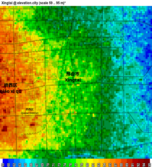
Below is the Elevation map of Xingtai, which displays elevation range with different colors. Scale of the first map is from 59 to 95 m (194 to 312 ft) with average elevation of 74.1 meters (=243 ft) [note 1]
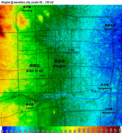
These maps also provides idea of topography and contour of this city, they are displayed at different zoom levels. More info about maps, scale and edge coordinates you can find below images.
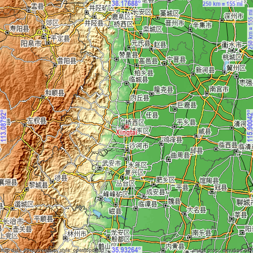
| \ | Map #1 | Map #2 | Topo.Map |
| Scale [m] | 59..95 m | 50..130 m | × |
| Scale [ft] | 194..312 ft | 164..427 ft | × |
| Average | 74.1 m = 243 ft | 75.7 m = 248 ft | × |
| Width | 7.8 km = 4.8 mi | 15.6 km = 9.7 mi | 249.5 km = 155 mi |
| Height | 7.8 km = 4.8 mi | 15.6 km = 9.7 mi | 249.5 km = 155 mi |
| ↑Max Latitude | 37.098119° | 37.133162° | 38.17688° |
| Latitude at center | 37.06306° | 37.06306° | 37.06306° |
| ↓Min Latitude | 37.027985° | 36.992893° | 35.93264° |
| ← Min Longitude | 114.450225° | 114.406279° | 113.08792° |
| Longitude center | 114.49417° | 114.49417° | 114.49417° |
| →Max Longitude | 114.538115° | 114.582061° | 115.90042° |
Nearby cities:
Cities around Xingtai sort by population:
• Handan elevation 66 m
51.5 km,  182°
182°
• Luancheng 55 m
91.8 km,  8°
8°
• Shahecheng 73 m
13.9 km, 175°
• Linshui 138 m
75.5 km,  199°
199°
• Hecun 247 m
68.1 km,  210°
210°
• Nangong 29 m
84.6 km,  67°
67°
• Pengcheng 147 m
76 km, 202°
• Leping 914 m
95.6 km,  309°
309°
• Guantao 43 m
91.1 km,  129°
129°
• Yixing 1379 m
89.9 km,  289°
289°
• Mingzhou 39 m
68.4 km,  98°
98°
• Xinmatou 41 m
66 km,  114°
114°
Multilingual:
 En español:
Xingtai elevación 76 m.
 En France:
Xingtai élévation 76 m.


Sources and notes:
- [note 1] Map square and city borders are not equal. Map elevation data is calculated only from area inside that square.
- [src 1] Elevation data from geonames database provided with same terms of usage.
- [src 2] The elevation map of Xingtai is generated using elevation data from NASA's 3 arcsec (90m) resolution SRTM data.
- [src 3] Base (background) map © OpenStreetMap contributors tiles are generated by Geofabrik and OpenTopoMap.
Copyright & License:
This Xingtai Elevation Map is licensed under CC BY-SA. You may reuse any part from this page, if you give a proper credit by linking to this URL:
 More info on terms of use page.