Huazangsi elevation
Huazangsi (Gansu), China elevation is 2407 meters and Huazangsi elevation in feet is 7897 ft above sea level [src 1]. Huazangsi is a seat of a third-order administrative division (feature code) with elevation that is 1849 meters (6066 ft) bigger than average city elevation in China.
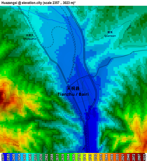
Below is the Elevation map of Huazangsi, which displays elevation range with different colors. Scale of the first map is from 2357 to 3023 m (7733 to 9918 ft) with average elevation of 2537.9 meters (=8326 ft) [note 1]
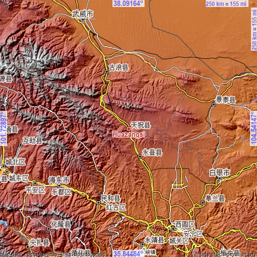
These maps also provides idea of topography and contour of this city, they are displayed at different zoom levels. More info about maps, scale and edge coordinates you can find below images.
| \ | Map #1 | Topo.Map |
| Scale [m] | 2357..3023 m | × |
| Scale [ft] | 7733..9918 ft | × |
| Average | 2537.9 m = 8326 ft | × |
| Width | 7.81 km = 4.9 mi | 249.8 km = 155.2 mi |
| Height | 7.81 km = 4.9 mi | 249.8 km = 155.2 mi |
| ↑Max Latitude | 37.011629° | 38.09164° |
| Latitude at center | 36.97653° | 36.97653° |
| ↓Min Latitude | 36.941415° | 35.84484° |
| ← Min Longitude | 103.091275° | 101.72897° |
| Longitude center | 103.13522° | 103.13522° |
| →Max Longitude | 103.179165° | 104.54147° |
Nearby cities:
Cities around Huazangsi sort by population:
• Wuwei elevation 1542 m
114.6 km,  337°
337°
• Baiyin 1723 m
103.8 km,  117°
117°
• Dongdajie 1538 m
114.5 km, 337°
• Anning Xilu 1539 m
110.2 km,  151°
151°
• Fulilu 1565 m
106.3 km,  156°
156°
• Renminlu 1734 m
103.6 km, 117°
• Weiyuan 2592 m
102.6 km,  262°
262°
• Gaolan Chengguanzhen 1654 m
101.6 km,  134°
134°
• Yitiaoshan 1616 m
84.5 km,  76°
76°
• Haishiwan 1775 m
74.3 km,  199°
199°
• Gulang 2086 m
58.5 km, 338°
• Yongdeng Chengguanzhen 2103 m
29.2 km, 157°
Multilingual:
 En español:
Huazangsi elevación 2407 m.
 En France:
Huazangsi élévation 2407 m.
 Auf Deutsch:
Huazangsi höhe über dem Meeresspiegel ist 2407 m.

Sources and notes:
- [note 1] Map square and city borders are not equal. Map elevation data is calculated only from area inside that square.
- [src 1] Elevation data from geonames database provided with same terms of usage.
- [src 2] The elevation map of Huazangsi is generated using elevation data from NASA's 3 arcsec (90m) resolution SRTM data.
- [src 3] Base (background) map © OpenStreetMap contributors tiles are generated by Geofabrik and OpenTopoMap.
Copyright & License:
This Huazangsi Elevation Map is licensed under CC BY-SA. You may reuse any part from this page, if you give a proper credit by linking to this URL:
 More info on terms of use page.