Gulang elevation
Gulang (Gansu), China elevation is 2086 meters and Gulang elevation in feet is 6844 ft above sea level [src 1]. Gulang is a seat of a third-order administrative division (feature code) with elevation that is 1528 meters (5013 ft) bigger than average city elevation in China.
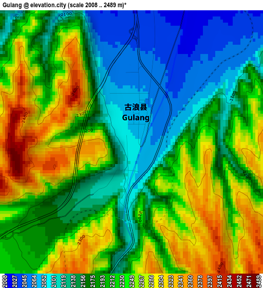
Below is the Elevation map of Gulang, which displays elevation range with different colors. Scale of the first map is from 2008 to 2489 m (6588 to 8166 ft) with average elevation of 2200.8 meters (=7220 ft) [note 1]
These maps also provides idea of topography and contour of this city, they are displayed at different zoom levels. More info about maps, scale and edge coordinates you can find below images.
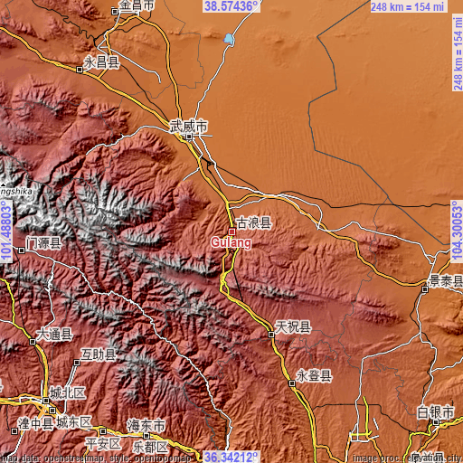
| \ | Map #1 | Topo.Map |
| Scale [m] | 2008..2489 m | × |
| Scale [ft] | 6588..8166 ft | × |
| Average | 2200.8 m = 7220 ft | × |
| Width | 7.76 km = 4.8 mi | 248.2 km = 154.2 mi |
| Height | 7.76 km = 4.8 mi | 248.2 km = 154.2 mi |
| ↑Max Latitude | 37.501442° | 38.57436° |
| Latitude at center | 37.46657° | 37.46657° |
| ↓Min Latitude | 37.431682° | 36.34212° |
| ← Min Longitude | 102.850335° | 101.48803° |
| Longitude center | 102.89428° | 102.89428° |
| →Max Longitude | 102.938225° | 104.30053° |
Nearby cities:
Cities around Gulang sort by population:
• Wuwei elevation 1542 m
56.1 km,  335°
335°
• Jinchang 1553 m
130.3 km,  331°
331°
• Guangzhoulu 1562 m
131.3 km, 331°
• Sanlei 1370 m
130.1 km,  7°
7°
• Haishiwan 1775 m
124.6 km,  181°
181°
• Qiaotou 2487 m
123.2 km,  241°
241°
• Yongchang Chengguanzhen 1919 m
117.8 km,  319°
319°
• Yitiaoshan 1616 m
109 km,  108°
108°
• Weiyuan 2592 m
105.1 km,  229°
229°
• Yongdeng Chengguanzhen 2103 m
87.7 km,  158°
158°
• Huazangsi 2407 m
58.5 km, 158°
• Dongdajie 1538 m
56.1 km, 335°
Multilingual:
 En español:
Gulang elevación 2086 m.
 En France:
Gulang élévation 2086 m.


Sources and notes:
- [note 1] Map square and city borders are not equal. Map elevation data is calculated only from area inside that square.
- [src 1] Elevation data from geonames database provided with same terms of usage.
- [src 2] The elevation map of Gulang is generated using elevation data from NASA's 3 arcsec (90m) resolution SRTM data.
- [src 3] Base (background) map © OpenStreetMap contributors tiles are generated by Geofabrik and OpenTopoMap.
Copyright & License:
This Gulang Elevation Map is licensed under CC BY-SA. You may reuse any part from this page, if you give a proper credit by linking to this URL:
 More info on terms of use page.