Jiehu elevation
Jiehu (Shandong), China elevation is 117 meters and Jiehu elevation in feet is 384 ft above sea level [src 1]. Jiehu is a populated place (feature code) with elevation that is 441 meters (1447 ft) smaller than average city elevation in China.
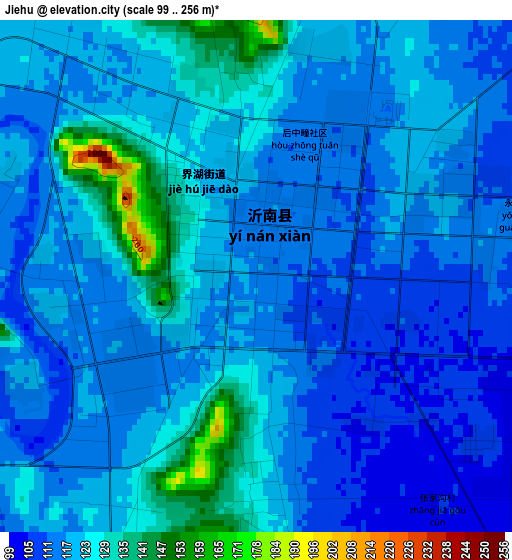
Below is the Elevation map of Jiehu, which displays elevation range with different colors. Scale of the first map is from 99 to 256 m (325 to 840 ft) with average elevation of 119.8 meters (=393 ft) [note 1]
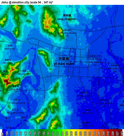
These maps also provides idea of topography and contour of this city, they are displayed at different zoom levels. More info about maps, scale and edge coordinates you can find below images.
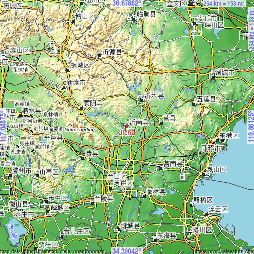
| \ | Map #1 | Map #2 | Topo.Map |
| Scale [m] | 99..256 m | 94..347 m | × |
| Scale [ft] | 325..840 ft | 308..1138 ft | × |
| Average | 119.8 m = 393 ft | 126.7 m = 416 ft | × |
| Width | 7.95 km = 4.9 mi | 15.9 km = 9.9 mi | 254.4 km = 158.1 mi |
| Height | 7.95 km = 4.9 mi | 15.9 km = 9.9 mi | 254.4 km = 158.1 mi |
| ↑Max Latitude | 35.57853° | 35.614263° | 36.67882° |
| Latitude at center | 35.54278° | 35.54278° | 35.54278° |
| ↓Min Latitude | 35.507015° | 35.471233° | 34.39042° |
| ← Min Longitude | 118.411055° | 118.367109° | 117.04875° |
| Longitude center | 118.455° | 118.455° | 118.455° |
| →Max Longitude | 118.498945° | 118.542891° | 119.86125° |
Nearby cities:
Cities around Jiehu sort by population:
• Linyi elevation 69 m
54.3 km,  190°
190°
• Xintai 197 m
74.9 km,  302°
302°
• Yishui 156 m
31.1 km,  30°
30°
• Shizilu 101 m
53.5 km,  140°
140°
• Feicheng 114 m
54.2 km,  234°
234°
• Pingyi 154 m
74.7 km,  266°
266°
• Nanma 283 m
76.3 km,  339°
339°
• Dongdu 200 m
76.3 km, 296°
• Chengyang 112 m
34.4 km,  83°
83°
• Mengyin 182 m
51.1 km,  290°
290°
• Bianzhuang 45 m
85.7 km,  205°
205°
• Xiazhuang 60 m
71.7 km,  166°
166°
Multilingual:
 En español:
Jiehu elevación 117 m.
 En France:
Jiehu élévation 117 m.


Sources and notes:
- [note 1] Map square and city borders are not equal. Map elevation data is calculated only from area inside that square.
- [src 1] Elevation data from geonames database provided with same terms of usage.
- [src 2] The elevation map of Jiehu is generated using elevation data from NASA's 3 arcsec (90m) resolution SRTM data.
- [src 3] Base (background) map © OpenStreetMap contributors tiles are generated by Geofabrik and OpenTopoMap.
Copyright & License:
This Jiehu Elevation Map is licensed under CC BY-SA. You may reuse any part from this page, if you give a proper credit by linking to this URL:
 More info on terms of use page.