Feicheng elevation
Feicheng (Shandong), China elevation is 114 meters and Feicheng elevation in feet is 374 ft above sea level [src 1]. Feicheng is a populated place (feature code) with elevation that is 444 meters (1457 ft) smaller than average city elevation in China.
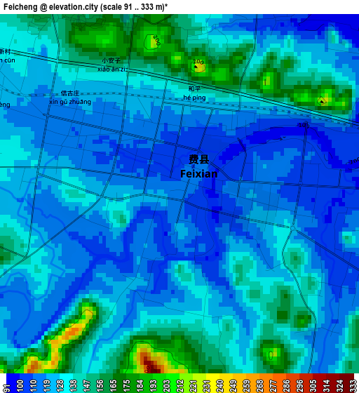
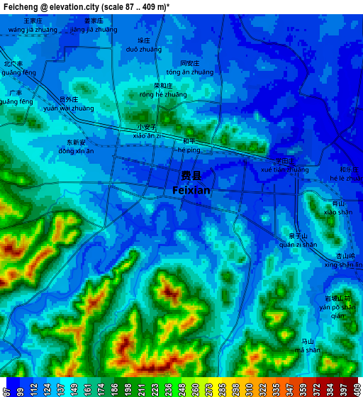
Below is the Elevation map of Feicheng, which displays elevation range with different colors. Scale of the first map is from 91 to 333 m (299 to 1093 ft) with average elevation of 130 meters (=427 ft) [note 1]
These maps also provides idea of topography and contour of this city, they are displayed at different zoom levels. More info about maps, scale and edge coordinates you can find below images.
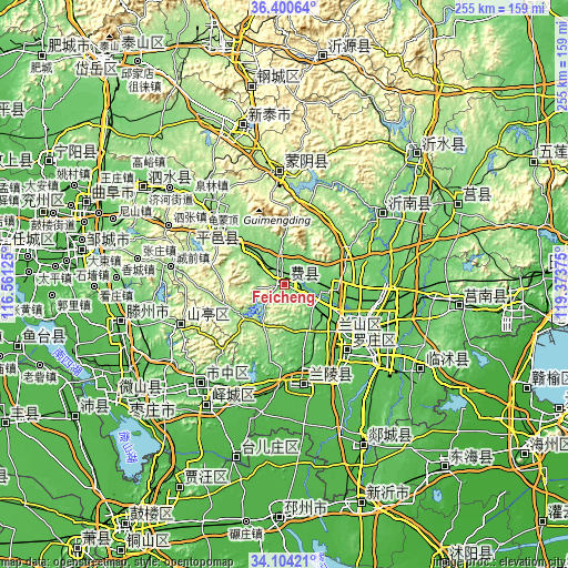
| \ | Map #1 | Map #2 | Topo.Map |
| Scale [m] | 91..333 m | 87..409 m | × |
| Scale [ft] | 299..1093 ft | 285..1342 ft | × |
| Average | 130 m = 427 ft | 147.4 m = 484 ft | × |
| Width | 7.98 km = 5 mi | 15.96 km = 9.9 mi | 255.3 km = 158.6 mi |
| Height | 7.98 km = 5 mi | 15.96 km = 9.9 mi | 255.3 km = 158.6 mi |
| ↑Max Latitude | 35.296435° | 35.332294° | 36.40064° |
| Latitude at center | 35.26056° | 35.26056° | 35.26056° |
| ↓Min Latitude | 35.224669° | 35.188762° | 34.10421° |
| ← Min Longitude | 117.923555° | 117.879609° | 116.56125° |
| Longitude center | 117.9675° | 117.9675° | 117.9675° |
| →Max Longitude | 118.011445° | 118.055391° | 119.37375° |
Nearby cities:
Cities around Feicheng sort by population:
• Linyi elevation 69 m
40.6 km,  122°
122°
• Xintai 197 m
73.8 km,  344°
344°
• Zaozhuang 79 m
57.9 km,  220°
220°
• Chengtangcun 73 m
73.3 km,  254°
254°
• Shanting 146 m
50.7 km, 246°
• Pingyi 154 m
40.5 km,  311°
311°
• Dongdu 200 m
69.9 km, 339°
• Jiehu 117 m
54.2 km,  54°
54°
• Mengyin 182 m
49.8 km,  355°
355°
• Bianzhuang 45 m
46.3 km,  171°
171°
• Xiazhuang 60 m
72.1 km, 122°
• Taozhuang 53 m
73.6 km,  231°
231°
Multilingual:
 En español:
Feicheng elevación 114 m.
 En France:
Feicheng élévation 114 m.
 Auf Deutsch:
Feicheng höhe über dem Meeresspiegel ist 114 m.

Sources and notes:
- [note 1] Map square and city borders are not equal. Map elevation data is calculated only from area inside that square.
- [src 1] Elevation data from geonames database provided with same terms of usage.
- [src 2] The elevation map of Feicheng is generated using elevation data from NASA's 3 arcsec (90m) resolution SRTM data.
- [src 3] Base (background) map © OpenStreetMap contributors tiles are generated by Geofabrik and OpenTopoMap.
Copyright & License:
This Feicheng Elevation Map is licensed under CC BY-SA. You may reuse any part from this page, if you give a proper credit by linking to this URL:
 More info on terms of use page.