Linfen elevation
Linfen (Shanxi), China elevation is 451 meters and Linfen elevation in feet is 1480 ft above sea level [src 1]. Linfen is a populated place (feature code) with elevation that is 107 meters (351 ft) smaller than average city elevation in China.
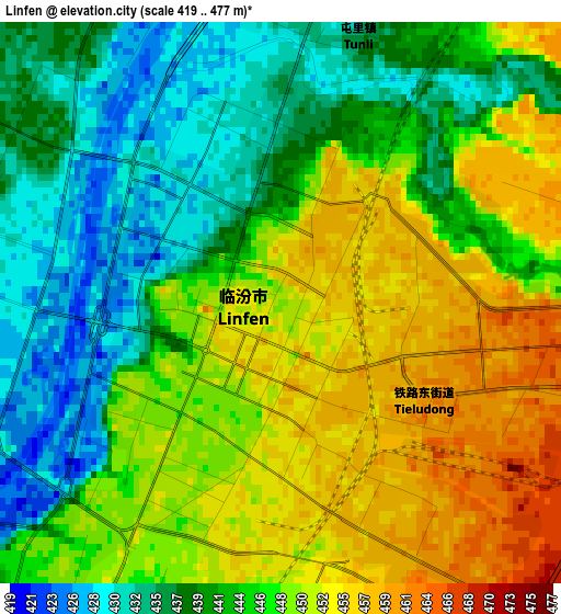
Below is the Elevation map of Linfen, which displays elevation range with different colors. Scale of the first map is from 419 to 477 m (1375 to 1565 ft) with average elevation of 445 meters (=1460 ft) [note 1]
These maps also provides idea of topography and contour of this city, they are displayed at different zoom levels. More info about maps, scale and edge coordinates you can find below images.
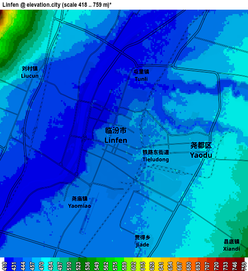
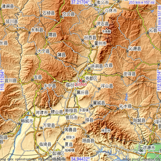
| \ | Map #1 | Map #2 | Topo.Map |
| Scale [m] | 419..477 m | 418..759 m | × |
| Scale [ft] | 1375..1565 ft | 1371..2490 ft | × |
| Average | 445 m = 1460 ft | 455.4 m = 1494 ft | × |
| Width | 7.9 km = 4.9 mi | 15.79 km = 9.8 mi | 252.7 km = 157 mi |
| Height | 7.9 km = 4.9 mi | 15.79 km = 9.8 mi | 252.7 km = 157 mi |
| ↑Max Latitude | 36.124394° | 36.159883° | 37.21704° |
| Latitude at center | 36.08889° | 36.08889° | 36.08889° |
| ↓Min Latitude | 36.05337° | 36.017833° | 34.94432° |
| ← Min Longitude | 111.474945° | 111.430999° | 110.11264° |
| Longitude center | 111.51889° | 111.51889° | 111.51889° |
| →Max Longitude | 111.562835° | 111.606781° | 112.92514° |
Nearby cities:
Cities around Linfen sort by population:
• Xinzhi elevation 519 m
48.5 km,  20°
20°
• Changning 1159 m
63.8 km,  259°
259°
• Yong’an 924 m
63.4 km,  3°
3°
• Longxing 401 m
59.4 km,  207°
207°
• Xintian 423 m
54.8 km,  195°
195°
• Pucheng 958 m
52.4 km,  313°
313°
• Lechang 460 m
49.9 km,  185°
185°
• Yueyang 865 m
41.9 km,  57°
57°
• Tangxing 603 m
41.5 km,  157°
157°
• Tiantan 835 m
32.1 km,  115°
115°
• Xincheng 434 m
24.9 km, 197°
• Dahuaishu 460 m
24.1 km,  35°
35°
Multilingual:
 En español:
Linfen elevación 451 m.
 En France:
Linfen élévation 451 m.
 Auf Deutsch:
Linfen höhe über dem Meeresspiegel ist 451 m.
 На русском:
Линьфынь, Линьфэнь высота над уровнем моря 451 м
Sources and notes:
- [note 1] Map square and city borders are not equal. Map elevation data is calculated only from area inside that square.
- [src 1] Elevation data from geonames database provided with same terms of usage.
- [src 2] The elevation map of Linfen is generated using elevation data from NASA's 3 arcsec (90m) resolution SRTM data.
- [src 3] Base (background) map © OpenStreetMap contributors tiles are generated by Geofabrik and OpenTopoMap.
Copyright & License:
This Linfen Elevation Map is licensed under CC BY-SA. You may reuse any part from this page, if you give a proper credit by linking to this URL:
 More info on terms of use page.