Lechang elevation
Lechang (Shanxi), China elevation is 460 meters and Lechang elevation in feet is 1509 ft above sea level [src 1]. Lechang is a seat of a third-order administrative division (feature code) with elevation that is 98 meters (322 ft) smaller than average city elevation in China.
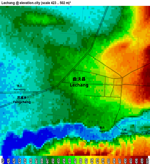
Below is the Elevation map of Lechang, which displays elevation range with different colors. Scale of the first map is from 423 to 502 m (1388 to 1647 ft) with average elevation of 452.7 meters (=1485 ft) [note 1]
These maps also provides idea of topography and contour of this city, they are displayed at different zoom levels. More info about maps, scale and edge coordinates you can find below images.
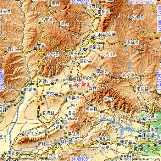
| \ | Map #1 | Topo.Map |
| Scale [m] | 423..502 m | × |
| Scale [ft] | 1388..1647 ft | × |
| Average | 452.7 m = 1485 ft | × |
| Width | 7.94 km = 4.9 mi | 254.1 km = 157.9 mi |
| Height | 7.94 km = 4.9 mi | 254.1 km = 157.9 mi |
| ↑Max Latitude | 35.677715° | 36.77662° |
| Latitude at center | 35.64201° | 35.64201° |
| ↓Min Latitude | 35.606289° | 34.49105° |
| ← Min Longitude | 111.423275° | 110.06097° |
| Longitude center | 111.46722° | 111.46722° |
| →Max Longitude | 111.511165° | 112.87347° |
Nearby cities:
Cities around Lechang sort by population:
• Changzhi elevation 381 m
54.1 km,  152°
152°
• Linfen 451 m
49.9 km,  5°
5°
• Yaofeng 410 m
60.6 km,  202°
202°
• Tiantan 835 m
49.4 km,  43°
43°
• Jifeng 402 m
46.1 km,  266°
266°
• Xincheng 555 m
42 km, 154°
• Tongcheng 470 m
39.2 km,  215°
215°
• Xincheng 434 m
26.1 km,  353°
353°
• Tangxing 603 m
23.8 km,  61°
61°
• Longxing 401 m
22.6 km,  261°
261°
• Gujiang 734 m
18.2 km, 154°
• Xintian 423 m
10.5 km,  252°
252°
Multilingual:
 En español:
Lechang elevación 460 m.
 En France:
Lechang élévation 460 m.


Sources and notes:
- [note 1] Map square and city borders are not equal. Map elevation data is calculated only from area inside that square.
- [src 1] Elevation data from geonames database provided with same terms of usage.
- [src 2] The elevation map of Lechang is generated using elevation data from NASA's 3 arcsec (90m) resolution SRTM data.
- [src 3] Base (background) map © OpenStreetMap contributors tiles are generated by Geofabrik and OpenTopoMap.
Copyright & License:
This Lechang Elevation Map is licensed under CC BY-SA. You may reuse any part from this page, if you give a proper credit by linking to this URL:
 More info on terms of use page.