Changning elevation
Changning (Shanxi), China elevation is 1159 meters and Changning elevation in feet is 3802 ft above sea level [src 1]. Changning is a seat of a third-order administrative division (feature code) with elevation that is 601 meters (1972 ft) bigger than average city elevation in China.
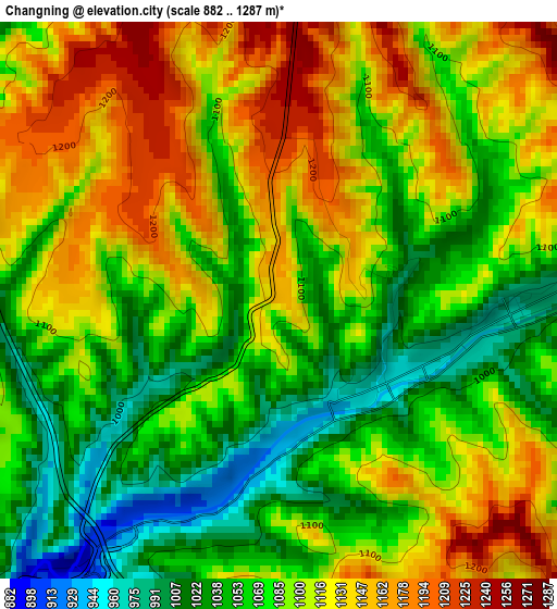
Below is the Elevation map of Changning, which displays elevation range with different colors. Scale of the first map is from 882 to 1287 m (2894 to 4222 ft) with average elevation of 1091.8 meters (=3582 ft) [note 1]
These maps also provides idea of topography and contour of this city, they are displayed at different zoom levels. More info about maps, scale and edge coordinates you can find below images.
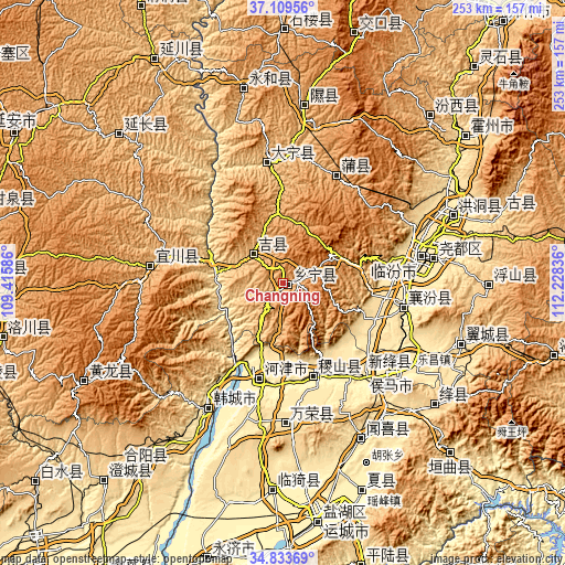
| \ | Map #1 | Topo.Map |
| Scale [m] | 882..1287 m | × |
| Scale [ft] | 2894..4222 ft | × |
| Average | 1091.8 m = 3582 ft | × |
| Width | 7.91 km = 4.9 mi | 253.1 km = 157.3 mi |
| Height | 7.91 km = 4.9 mi | 253.1 km = 157.3 mi |
| ↑Max Latitude | 36.015384° | 37.10956° |
| Latitude at center | 35.97983° | 35.97983° |
| ↓Min Latitude | 35.94426° | 34.83369° |
| ← Min Longitude | 110.778165° | 109.41586° |
| Longitude center | 110.82211° | 110.82211° |
| →Max Longitude | 110.866055° | 112.22836° |
Nearby cities:
Cities around Changning sort by population:
• Linfen elevation 451 m
63.8 km,  79°
79°
• Hancheng 383 m
67.8 km,  211°
211°
• Tongcheng 470 m
78.1 km,  152°
152°
• Lechang 460 m
69.2 km,  122°
122°
• Xintian 423 m
63.1 km,  130°
130°
• Xiedian 578 m
61.3 km,  180°
180°
• Xincheng 434 m
56.4 km,  101°
101°
• Xinshui 846 m
55.8 km,  353°
353°
• Longxing 401 m
54.3 km,  138°
138°
• Pucheng 958 m
54.1 km,  26°
26°
• Jifeng 402 m
42.6 km,  163°
163°
• Jichang 882 m
19 km,  315°
315°
Multilingual:
 En español:
Changning elevación 1159 m.
 En France:
Changning élévation 1159 m.
 Auf Deutsch:
Changning höhe über dem Meeresspiegel ist 1159 m.

Sources and notes:
- [note 1] Map square and city borders are not equal. Map elevation data is calculated only from area inside that square.
- [src 1] Elevation data from geonames database provided with same terms of usage.
- [src 2] The elevation map of Changning is generated using elevation data from NASA's 3 arcsec (90m) resolution SRTM data.
- [src 3] Base (background) map © OpenStreetMap contributors tiles are generated by Geofabrik and OpenTopoMap.
Copyright & License:
This Changning Elevation Map is licensed under CC BY-SA. You may reuse any part from this page, if you give a proper credit by linking to this URL:
 More info on terms of use page.