Nanchong elevation
Nanchong (Sichuan), China elevation is 287 meters and Nanchong elevation in feet is 942 ft above sea level [src 1]. Nanchong is a seat of a third-order administrative division (feature code) with elevation that is 271 meters (889 ft) smaller than average city elevation in China.
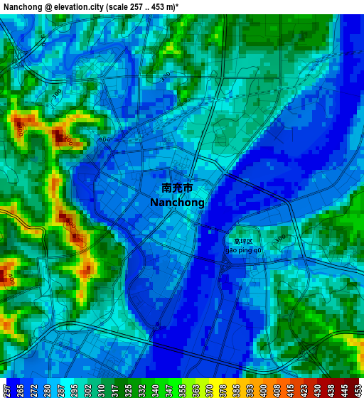
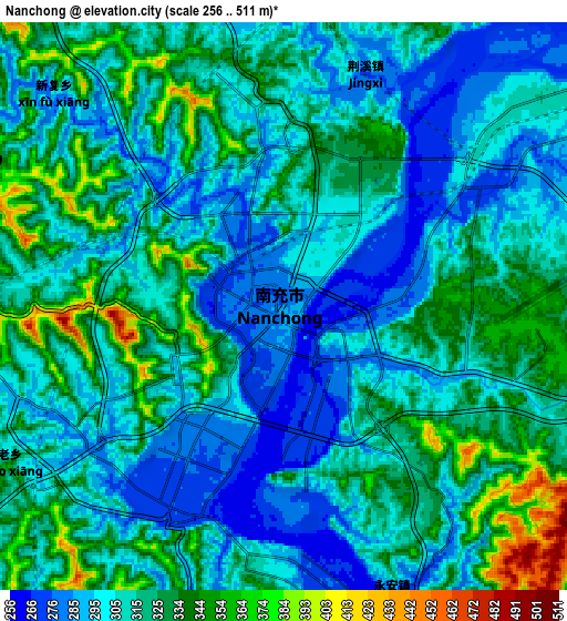
Below is the Elevation map of Nanchong, which displays elevation range with different colors. Scale of the first map is from 257 to 453 m (843 to 1486 ft) with average elevation of 296.1 meters (=971 ft) [note 1]
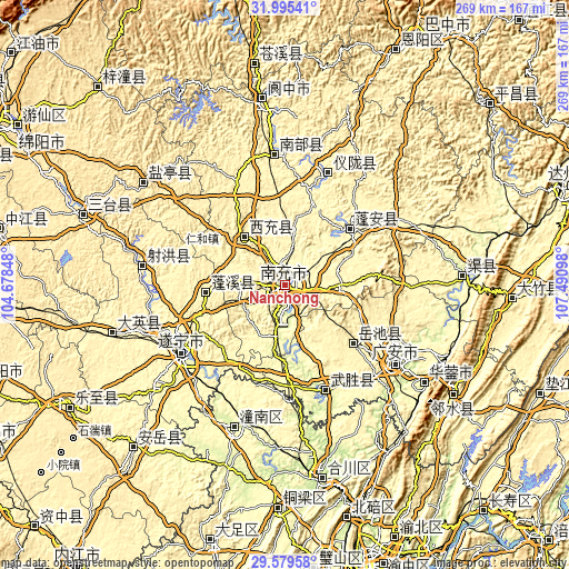
These maps also provides idea of topography and contour of this city, they are displayed at different zoom levels. More info about maps, scale and edge coordinates you can find below images.
| \ | Map #1 | Map #2 | Topo.Map |
| Scale [m] | 257..453 m | 256..511 m | × |
| Scale [ft] | 843..1486 ft | 840..1677 ft | × |
| Average | 296.1 m = 971 ft | 313.9 m = 1030 ft | × |
| Width | 8.39 km = 5.2 mi | 16.79 km = 10.4 mi | 268.6 km = 166.9 mi |
| Height | 8.39 km = 5.2 mi | 16.79 km = 10.4 mi | 268.6 km = 166.9 mi |
| ↑Max Latitude | 30.832822° | 30.870549° | 31.99541° |
| Latitude at center | 30.79508° | 30.79508° | 30.79508° |
| ↓Min Latitude | 30.757323° | 30.719552° | 29.57958° |
| ← Min Longitude | 106.040785° | 105.996839° | 104.67848° |
| Longitude center | 106.08473° | 106.08473° | 106.08473° |
| →Max Longitude | 106.128675° | 106.172621° | 107.49098° |
Nearby cities:
Cities around Nanchong sort by population:
• Gaoping elevation 283 m
2.8 km,  141°
141°
• Suining 291 m
58.4 km,  236°
236°
• Nanlong 352 m
62.1 km,  358°
358°
• Guang’an 244 m
63.8 km,  124°
124°
• Xinzheng 333 m
56.7 km,  19°
19°
• Langchi 335 m
55.7 km,  55°
55°
• Yankou 288 m
53 km,  158°
158°
• Jiulong 387 m
44.3 km,  130°
130°
• Zhoukou 320 m
40.3 km,  48°
48°
• Chicheng 347 m
35.6 km,  267°
267°
• Jincheng 332 m
29.7 km,  319°
319°
• Huohua 277 m
4.7 km,  211°
211°
Multilingual:
 En español:
Nanchong elevación 287 m.
 En France:
Nanchong élévation 287 m.
 Auf Deutsch:
Nanchong höhe über dem Meeresspiegel ist 287 m.

Sources and notes:
- [note 1] Map square and city borders are not equal. Map elevation data is calculated only from area inside that square.
- [src 1] Elevation data from geonames database provided with same terms of usage.
- [src 2] The elevation map of Nanchong is generated using elevation data from NASA's 3 arcsec (90m) resolution SRTM data.
- [src 3] Base (background) map © OpenStreetMap contributors tiles are generated by Geofabrik and OpenTopoMap.
Copyright & License:
This Nanchong Elevation Map is licensed under CC BY-SA. You may reuse any part from this page, if you give a proper credit by linking to this URL:
 More info on terms of use page.