Yankou elevation
Yankou (Sichuan), China elevation is 288 meters and Yankou elevation in feet is 945 ft above sea level [src 1]. Yankou is a seat of a third-order administrative division (feature code) with elevation that is 270 meters (886 ft) smaller than average city elevation in China.
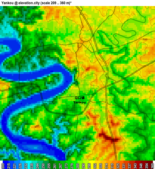
Below is the Elevation map of Yankou, which displays elevation range with different colors. Scale of the first map is from 209 to 360 m (686 to 1181 ft) with average elevation of 275.7 meters (=905 ft) [note 1]
These maps also provides idea of topography and contour of this city, they are displayed at different zoom levels. More info about maps, scale and edge coordinates you can find below images.
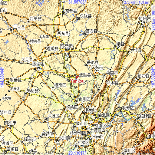
| \ | Map #1 | Topo.Map |
| Scale [m] | 209..360 m | × |
| Scale [ft] | 686..1181 ft | × |
| Average | 275.7 m = 905 ft | × |
| Width | 8.43 km = 5.2 mi | 269.8 km = 167.6 mi |
| Height | 8.43 km = 5.2 mi | 269.9 km = 167.7 mi |
| ↑Max Latitude | 30.389065° | 31.55708° |
| Latitude at center | 30.35115° | 30.35115° |
| ↓Min Latitude | 30.31322° | 29.13017° |
| ← Min Longitude | 106.242745° | 104.88044° |
| Longitude center | 106.28669° | 106.28669° |
| →Max Longitude | 106.330635° | 107.69294° |
Nearby cities:
Cities around Yankou sort by population:
• Nanchong elevation 287 m
53 km,  338°
338°
• Gaoping 283 m
50.4 km, 339°
• Beibei 237 m
60 km,  166°
166°
• Hechuan 222 m
40 km,  183°
183°
• Bachuan 279 m
60.3 km,  202°
202°
• Beiwenquan 243 m
58.9 km, 167°
• Huohua 277 m
50.3 km,  334°
334°
• Zitong 258 m
47.9 km,  246°
246°
• Shuanghejiedao 256 m
46.7 km,  86°
86°
• Nanjin 223 m
40.8 km, 182°
• Guang’an 244 m
36.3 km,  67°
67°
• Jiulong 387 m
25.1 km,  35°
35°
Multilingual:
 En español:
Yankou elevación 288 m.
 En France:
Yankou élévation 288 m.


Sources and notes:
- [note 1] Map square and city borders are not equal. Map elevation data is calculated only from area inside that square.
- [src 1] Elevation data from geonames database provided with same terms of usage.
- [src 2] The elevation map of Yankou is generated using elevation data from NASA's 3 arcsec (90m) resolution SRTM data.
- [src 3] Base (background) map © OpenStreetMap contributors tiles are generated by Geofabrik and OpenTopoMap.
Copyright & License:
This Yankou Elevation Map is licensed under CC BY-SA. You may reuse any part from this page, if you give a proper credit by linking to this URL:
 More info on terms of use page.