Suining elevation
Suining (Sichuan), China elevation is 291 meters and Suining elevation in feet is 955 ft above sea level [src 1]. Suining is a seat of a third-order administrative division (feature code) with elevation that is 267 meters (876 ft) smaller than average city elevation in China.
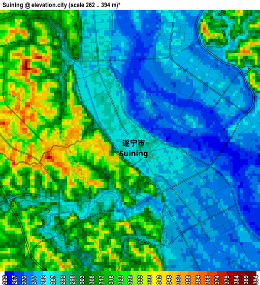
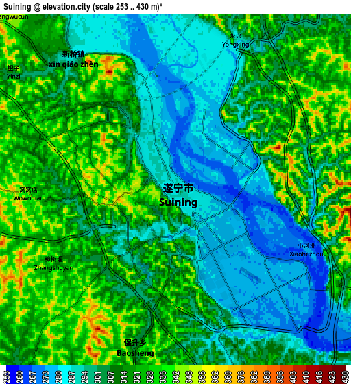
Below is the Elevation map of Suining, which displays elevation range with different colors. Scale of the first map is from 262 to 394 m (860 to 1293 ft) with average elevation of 298.8 meters (=980 ft) [note 1]
These maps also provides idea of topography and contour of this city, they are displayed at different zoom levels. More info about maps, scale and edge coordinates you can find below images.
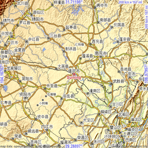
| \ | Map #1 | Map #2 | Topo.Map |
| Scale [m] | 262..394 m | 253..430 m | × |
| Scale [ft] | 860..1293 ft | 830..1411 ft | × |
| Average | 298.8 m = 980 ft | 310 m = 1017 ft | × |
| Width | 8.42 km = 5.2 mi | 16.84 km = 10.5 mi | 269.4 km = 167.4 mi |
| Height | 8.42 km = 5.2 mi | 16.84 km = 10.5 mi | 269.4 km = 167.4 mi |
| ↑Max Latitude | 30.545874° | 30.583713° | 31.71198° |
| Latitude at center | 30.50802° | 30.50802° | 30.50802° |
| ↓Min Latitude | 30.470151° | 30.432268° | 29.28897° |
| ← Min Longitude | 105.529375° | 105.485429° | 104.16707° |
| Longitude center | 105.57332° | 105.57332° | 105.57332° |
| →Max Longitude | 105.617265° | 105.661211° | 106.97957° |
Nearby cities:
Cities around Suining sort by population:
• Nanchong elevation 287 m
58.4 km,  56°
56°
• Gaoping 283 m
58.8 km, 59°
• Tongchuan 386 m
80 km,  324°
324°
• Yankou 288 m
70.6 km,  104°
104°
• Jincheng 332 m
61.9 km,  28°
28°
• Tianchi 440 m
58.5 km,  244°
244°
• Huohua 277 m
54.2 km, 59°
• Taihe 337 m
44.2 km,  335°
335°
• Zitong 258 m
44.2 km,  146°
146°
• Chicheng 347 m
33 km,  23°
23°
• Penglai 316 m
31.9 km,  284°
284°
• Anju 290 m
20.9 km,  212°
212°
Multilingual:
 En español:
Suining elevación 291 m.
 En France:
Suining élévation 291 m.


Sources and notes:
- [note 1] Map square and city borders are not equal. Map elevation data is calculated only from area inside that square.
- [src 1] Elevation data from geonames database provided with same terms of usage.
- [src 2] The elevation map of Suining is generated using elevation data from NASA's 3 arcsec (90m) resolution SRTM data.
- [src 3] Base (background) map © OpenStreetMap contributors tiles are generated by Geofabrik and OpenTopoMap.
Copyright & License:
This Suining Elevation Map is licensed under CC BY-SA. You may reuse any part from this page, if you give a proper credit by linking to this URL:
 More info on terms of use page.