Jiyuanlu elevation
Jiyuanlu (Henan), China elevation is 149 meters and Jiyuanlu elevation in feet is 489 ft above sea level [src 1]. Jiyuanlu is a seat of a third-order administrative division (feature code) with elevation that is 409 meters (1342 ft) smaller than average city elevation in China.
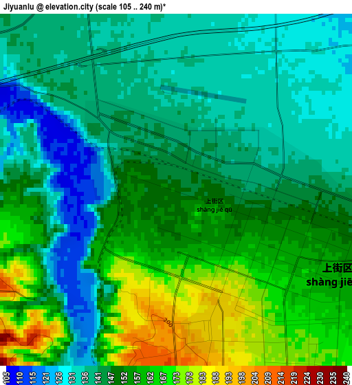
Below is the Elevation map of Jiyuanlu, which displays elevation range with different colors. Scale of the first map is from 105 to 240 m (344 to 787 ft) with average elevation of 148.6 meters (=488 ft) [note 1]
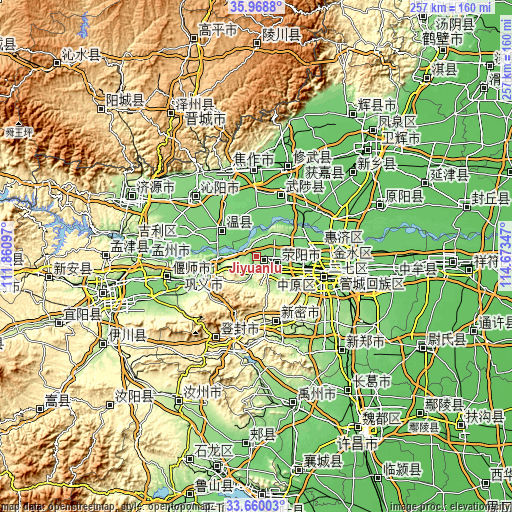
These maps also provides idea of topography and contour of this city, they are displayed at different zoom levels. More info about maps, scale and edge coordinates you can find below images.
| \ | Map #1 | Topo.Map |
| Scale [m] | 105..240 m | × |
| Scale [ft] | 344..787 ft | × |
| Average | 148.6 m = 488 ft | × |
| Width | 8.02 km = 5 mi | 256.7 km = 159.5 mi |
| Height | 8.02 km = 5 mi | 256.7 km = 159.5 mi |
| ↑Max Latitude | 34.858568° | 35.9688° |
| Latitude at center | 34.8225° | 34.8225° |
| ↓Min Latitude | 34.786416° | 33.66003° |
| ← Min Longitude | 113.223275° | 111.86097° |
| Longitude center | 113.26722° | 113.26722° |
| →Max Longitude | 113.311165° | 114.67347° |
Nearby cities:
Cities around Jiyuanlu sort by population:
• Zhengzhou elevation 104 m
35.6 km,  101°
101°
• Zijinglu 136 m
27.9 km,  255°
255°
• Huichang 117 m
45 km,  281°
281°
• Yanshi Chengguanzhen 114 m
44.7 km,  254°
254°
• Qinghua 125 m
42.4 km,  333°
333°
• Tanbei 120 m
42 km,  314°
314°
• Huaihelu 112 m
36.2 km,  109°
109°
• Qingping 305 m
33.3 km,  162°
162°
• Mucheng 96 m
32.4 km,  20°
20°
• Jianshelu 119 m
31.9 km, 103°
• Wenquan 112 m
21.7 km, 305°
• Suohe 152 m
9.2 km,  115°
115°
Multilingual:
 En español:
Jiyuanlu elevación 149 m.
 En France:
Jiyuanlu élévation 149 m.
 Auf Deutsch:
Jiyuanlu höhe über dem Meeresspiegel ist 149 m.

Sources and notes:
- [note 1] Map square and city borders are not equal. Map elevation data is calculated only from area inside that square.
- [src 1] Elevation data from geonames database provided with same terms of usage.
- [src 2] The elevation map of Jiyuanlu is generated using elevation data from NASA's 3 arcsec (90m) resolution SRTM data.
- [src 3] Base (background) map © OpenStreetMap contributors tiles are generated by Geofabrik and OpenTopoMap.
Copyright & License:
This Jiyuanlu Elevation Map is licensed under CC BY-SA. You may reuse any part from this page, if you give a proper credit by linking to this URL:
 More info on terms of use page.