Tanbei elevation
Tanbei (Henan), China elevation is 120 meters and Tanbei elevation in feet is 394 ft above sea level [src 1]. Tanbei is a seat of a third-order administrative division (feature code) with elevation that is 438 meters (1437 ft) smaller than average city elevation in China.
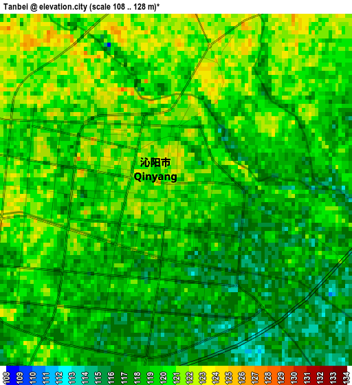
Below is the Elevation map of Tanbei, which displays elevation range with different colors. Scale of the first map is from 108 to 128 m (354 to 420 ft) with average elevation of 118.9 meters (=390 ft) [note 1]
These maps also provides idea of topography and contour of this city, they are displayed at different zoom levels. More info about maps, scale and edge coordinates you can find below images.
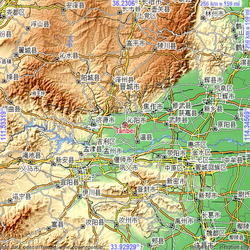
| \ | Map #1 | Topo.Map |
| Scale [m] | 108..128 m | × |
| Scale [ft] | 354..420 ft | × |
| Average | 118.9 m = 390 ft | × |
| Width | 8 km = 5 mi | 255.9 km = 159 mi |
| Height | 8 km = 5 mi | 255.9 km = 159 mi |
| ↑Max Latitude | 35.124011° | 36.2306° |
| Latitude at center | 35.08806° | 35.08806° |
| ↓Min Latitude | 35.052093° | 33.92929° |
| ← Min Longitude | 112.895495° | 111.53319° |
| Longitude center | 112.93944° | 112.93944° |
| →Max Longitude | 112.983385° | 114.34569° |
Nearby cities:
Cities around Tanbei sort by population:
• Jiaozuo elevation 138 m
31.6 km,  57°
57°
• Xixiang 132 m
10.7 km,  320°
320°
• Zijinglu 136 m
36.6 km,  175°
175°
• Yanshi Chengguanzhen 114 m
43.4 km,  197°
197°
• Jiyuanlu 149 m
42 km,  134°
134°
• Mucheng 96 m
41 km,  88°
88°
• Daqinglu 143 m
38.7 km,  237°
237°
• Jiyuan 152 m
32.7 km,  270°
270°
• Zhongzhan 190 m
26.3 km,  49°
49°
• Huichang 117 m
24.9 km,  214°
214°
• Wenquan 112 m
20.9 km,  144°
144°
• Qinghua 125 m
14 km, 52°
Multilingual:
 En español:
Tanbei elevación 120 m.
 En France:
Tanbei élévation 120 m.


Sources and notes:
- [note 1] Map square and city borders are not equal. Map elevation data is calculated only from area inside that square.
- [src 1] Elevation data from geonames database provided with same terms of usage.
- [src 2] The elevation map of Tanbei is generated using elevation data from NASA's 3 arcsec (90m) resolution SRTM data.
- [src 3] Base (background) map © OpenStreetMap contributors tiles are generated by Geofabrik and OpenTopoMap.
Copyright & License:
This Tanbei Elevation Map is licensed under CC BY-SA. You may reuse any part from this page, if you give a proper credit by linking to this URL:
 More info on terms of use page.