Feicheng elevation
Feicheng (Shandong), China elevation is 115 meters and Feicheng elevation in feet is 377 ft above sea level [src 1]. Feicheng is a populated place (feature code) with elevation that is 443 meters (1453 ft) smaller than average city elevation in China.
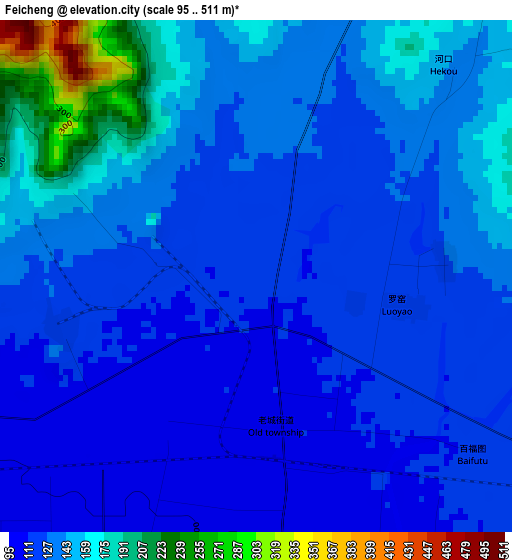
Below is the Elevation map of Feicheng, which displays elevation range with different colors. Scale of the first map is from 95 to 511 m (312 to 1677 ft) with average elevation of 134.7 meters (=442 ft) [note 1]
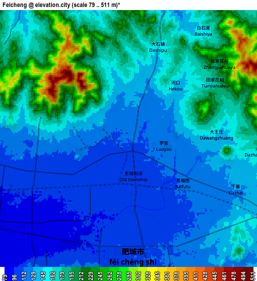
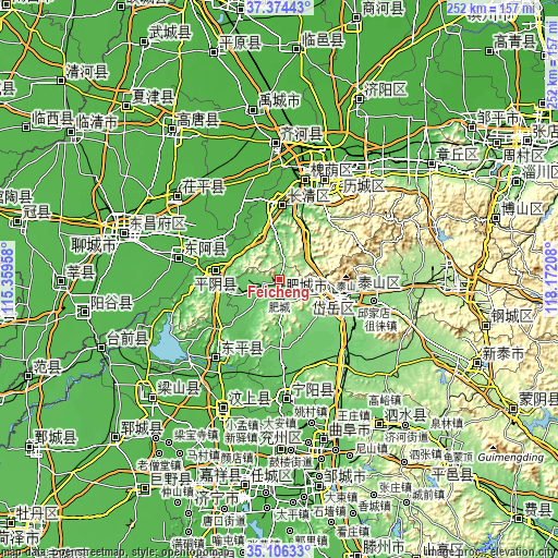
These maps also provides idea of topography and contour of this city, they are displayed at different zoom levels. More info about maps, scale and edge coordinates you can find below images.
| \ | Map #1 | Map #2 | Topo.Map |
| Scale [m] | 95..511 m | 79..511 m | × |
| Scale [ft] | 312..1677 ft | 259..1677 ft | × |
| Average | 134.7 m = 442 ft | 155.4 m = 510 ft | × |
| Width | 7.88 km = 4.9 mi | 15.76 km = 9.8 mi | 252.2 km = 156.7 mi |
| Height | 7.88 km = 4.9 mi | 15.76 km = 9.8 mi | 252.2 km = 156.7 mi |
| ↑Max Latitude | 36.284042° | 36.319458° | 37.37443° |
| Latitude at center | 36.24861° | 36.24861° | 36.24861° |
| ↓Min Latitude | 36.213162° | 36.177698° | 35.10633° |
| ← Min Longitude | 116.721885° | 116.677939° | 115.35958° |
| Longitude center | 116.76583° | 116.76583° | 116.76583° |
| →Max Longitude | 116.809775° | 116.853721° | 118.17208° |
Nearby cities:
Cities around Feicheng sort by population:
• Tai’an elevation 143 m
32.5 km,  102°
102°
• Jinan 32 m
51.1 km,  23°
23°
• Liaocheng 39 m
74.3 km,  288°
288°
• Qufu 69 m
75.3 km,  164°
164°
• Ningyang 65 m
53.9 km,  177°
177°
• Changqing 39 m
34.5 km,  354°
354°
• Yanzhou 54 m
77.6 km, 175°
• Zhoucheng 41 m
55.4 km,  227°
227°
• Pingyin 43 m
29 km,  277°
277°
• Wenshang 44 m
62.8 km,  202°
202°
• Gulou 41 m
75 km, 286°
• Yancheng 27 m
61.3 km,  358°
358°
Multilingual:
 En español:
Feicheng elevación 115 m.
 En France:
Feicheng élévation 115 m.
 Auf Deutsch:
Feicheng höhe über dem Meeresspiegel ist 115 m.

Sources and notes:
- [note 1] Map square and city borders are not equal. Map elevation data is calculated only from area inside that square.
- [src 1] Elevation data from geonames database provided with same terms of usage.
- [src 2] The elevation map of Feicheng is generated using elevation data from NASA's 3 arcsec (90m) resolution SRTM data.
- [src 3] Base (background) map © OpenStreetMap contributors tiles are generated by Geofabrik and OpenTopoMap.
Copyright & License:
This Feicheng Elevation Map is licensed under CC BY-SA. You may reuse any part from this page, if you give a proper credit by linking to this URL:
 More info on terms of use page.