Liaocheng elevation
Liaocheng (Shandong), China elevation is 39 meters and Liaocheng elevation in feet is 128 ft above sea level [src 1]. Liaocheng is a seat of a second-order administrative division (feature code) with elevation that is 519 meters (1703 ft) smaller than average city elevation in China.
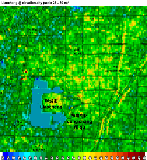
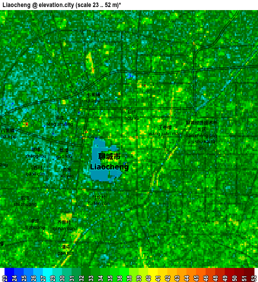
Below is the Elevation map of Liaocheng, which displays elevation range with different colors. Scale of the first map is from 23 to 50 m (75 to 164 ft) with average elevation of 33.9 meters (=111 ft) [note 1]
These maps also provides idea of topography and contour of this city, they are displayed at different zoom levels. More info about maps, scale and edge coordinates you can find below images.
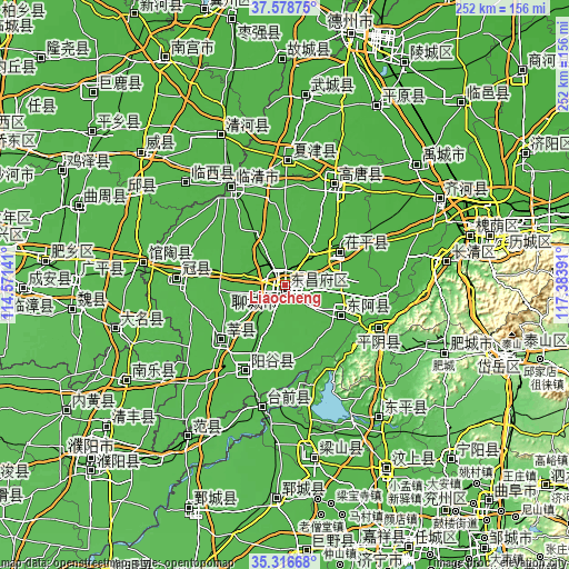
| \ | Map #1 | Map #2 | Topo.Map |
| Scale [m] | 23..50 m | 23..52 m | × |
| Scale [ft] | 75..164 ft | 75..171 ft | × |
| Average | 33.9 m = 111 ft | 33.4 m = 110 ft | × |
| Width | 7.86 km = 4.9 mi | 15.72 km = 9.8 mi | 251.5 km = 156.3 mi |
| Height | 7.86 km = 4.9 mi | 15.72 km = 9.8 mi | 251.5 km = 156.3 mi |
| ↑Max Latitude | 36.491298° | 36.526619° | 37.57875° |
| Latitude at center | 36.45596° | 36.45596° | 36.45596° |
| ↓Min Latitude | 36.420606° | 36.385236° | 35.31668° |
| ← Min Longitude | 115.933715° | 115.889769° | 114.57141° |
| Longitude center | 115.97766° | 115.97766° | 115.97766° |
| →Max Longitude | 116.021605° | 116.065551° | 117.38391° |
Nearby cities:
Cities around Liaocheng sort by population:
• Qingnian elevation 36 m
48.9 km,  330°
330°
• Changqing 39 m
67.9 km,  80°
80°
• Yanta 41 m
36.7 km,  229°
229°
• Yanggu 42 m
42.5 km,  205°
205°
• Zhoucheng 41 m
67.5 km,  153°
153°
• Pingyin 43 m
46.1 km,  114°
114°
• Xiliguantun 28 m
69.3 km,  357°
357°
• Yangying 41 m
71 km,  182°
182°
• Guantao 43 m
62.8 km,  278°
278°
• Nancheng 32 m
54.8 km,  1°
1°
• Guancheng 45 m
48.6 km,  273°
273°
• Gulou 41 m
1.8 km,  222°
222°
Multilingual:
 En español:
Liaocheng elevación 39 m.
 En France:
Liaocheng élévation 39 m.
 Auf Deutsch:
Liaocheng höhe über dem Meeresspiegel ist 39 m.

Sources and notes:
- [note 1] Map square and city borders are not equal. Map elevation data is calculated only from area inside that square.
- [src 1] Elevation data from geonames database provided with same terms of usage.
- [src 2] The elevation map of Liaocheng is generated using elevation data from NASA's 3 arcsec (90m) resolution SRTM data.
- [src 3] Base (background) map © OpenStreetMap contributors tiles are generated by Geofabrik and OpenTopoMap.
Copyright & License:
This Liaocheng Elevation Map is licensed under CC BY-SA. You may reuse any part from this page, if you give a proper credit by linking to this URL:
 More info on terms of use page.