Yanta elevation
Yanta (Shandong), China elevation is 41 meters and Yanta elevation in feet is 135 ft above sea level [src 1]. Yanta is a seat of a third-order administrative division (feature code) with elevation that is 517 meters (1696 ft) smaller than average city elevation in China.
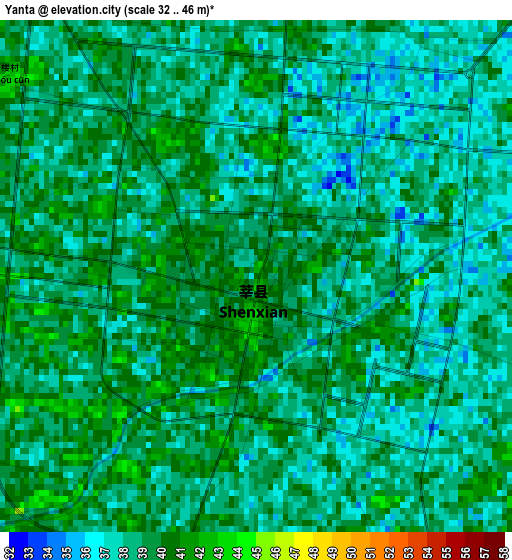
Below is the Elevation map of Yanta, which displays elevation range with different colors. Scale of the first map is from 32 to 46 m (105 to 151 ft) with average elevation of 38.4 meters (=126 ft) [note 1]
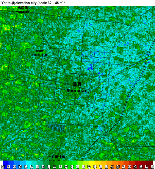
These maps also provides idea of topography and contour of this city, they are displayed at different zoom levels. More info about maps, scale and edge coordinates you can find below images.
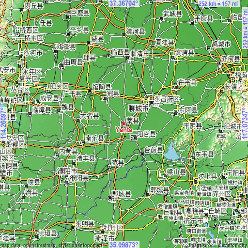
| \ | Map #1 | Map #2 | Topo.Map |
| Scale [m] | 32..46 m | 32..48 m | × |
| Scale [ft] | 105..151 ft | 105..157 ft | × |
| Average | 38.4 m = 126 ft | 39 m = 128 ft | × |
| Width | 7.88 km = 4.9 mi | 15.76 km = 9.8 mi | 252.2 km = 156.7 mi |
| Height | 7.88 km = 4.9 mi | 15.76 km = 9.8 mi | 252.2 km = 156.7 mi |
| ↑Max Latitude | 36.276545° | 36.311965° | 37.36704° |
| Latitude at center | 36.24111° | 36.24111° | 36.24111° |
| ↓Min Latitude | 36.205658° | 36.170191° | 35.09873° |
| ← Min Longitude | 115.623275° | 115.579329° | 114.26097° |
| Longitude center | 115.66722° | 115.66722° | 115.66722° |
| →Max Longitude | 115.711165° | 115.755111° | 117.07347° |
Nearby cities:
Cities around Yanta sort by population:
• Liaocheng elevation 39 m
36.7 km,  49°
49°
• Qingnian 36 m
66.7 km,  3°
3°
• Yanggu 42 m
17.5 km,  146°
146°
• Zhoucheng 41 m
68.5 km,  122°
122°
• Qingfeng Chengguanzhen 52 m
62.9 km,  233°
233°
• Yangying 41 m
53.4 km, 151°
• Guantao 43 m
47.9 km,  314°
314°
• Daming 48 m
47.2 km,  276°
276°
• Nanle Chengguanzhen 51 m
45.9 km,  246°
246°
• Fan Xian Chengguanzhen 48 m
45.1 km,  199°
199°
• Gulou 41 m
34.9 km, 49°
• Guancheng 45 m
33.8 km,  321°
321°
Multilingual:
 En español:
Yanta elevación 41 m.
 En France:
Yanta élévation 41 m.


Sources and notes:
- [note 1] Map square and city borders are not equal. Map elevation data is calculated only from area inside that square.
- [src 1] Elevation data from geonames database provided with same terms of usage.
- [src 2] The elevation map of Yanta is generated using elevation data from NASA's 3 arcsec (90m) resolution SRTM data.
- [src 3] Base (background) map © OpenStreetMap contributors tiles are generated by Geofabrik and OpenTopoMap.
Copyright & License:
This Yanta Elevation Map is licensed under CC BY-SA. You may reuse any part from this page, if you give a proper credit by linking to this URL:
 More info on terms of use page.