Tai’an elevation
Tai’an (Shandong), China elevation is 143 meters and Tai’an elevation in feet is 469 ft above sea level [src 1]. Tai’an is a populated place (feature code) with elevation that is 415 meters (1362 ft) smaller than average city elevation in China.
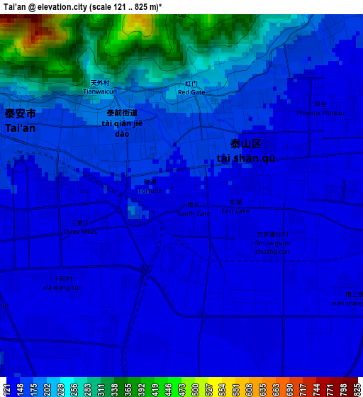
Below is the Elevation map of Tai’an, which displays elevation range with different colors. Scale of the first map is from 121 to 825 m (397 to 2707 ft) with average elevation of 175.4 meters (=575 ft) [note 1]
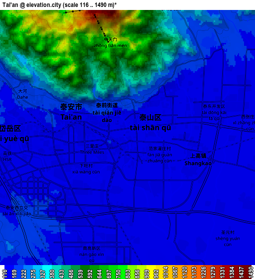
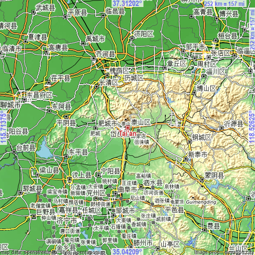
These maps also provides idea of topography and contour of this city, they are displayed at different zoom levels. More info about maps, scale and edge coordinates you can find below images.
| \ | Map #1 | Map #2 | Topo.Map |
| Scale [m] | 121..825 m | 116..1490 m | × |
| Scale [ft] | 397..2707 ft | 381..4888 ft | × |
| Average | 175.4 m = 575 ft | 248.9 m = 817 ft | × |
| Width | 7.89 km = 4.9 mi | 15.78 km = 9.8 mi | 252.4 km = 156.8 mi |
| Height | 7.89 km = 4.9 mi | 15.78 km = 9.8 mi | 252.4 km = 156.8 mi |
| ↑Max Latitude | 36.220741° | 36.256185° | 37.31202° |
| Latitude at center | 36.18528° | 36.18528° | 36.18528° |
| ↓Min Latitude | 36.149803° | 36.11431° | 35.04209° |
| ← Min Longitude | 117.076055° | 117.032109° | 115.71375° |
| Longitude center | 117.12° | 117.12° | 117.12° |
| →Max Longitude | 117.163945° | 117.207891° | 118.52625° |
Nearby cities:
Cities around Tai’an sort by population:
• Jinan elevation 32 m
54.8 km,  348°
348°
• Xintai 197 m
65 km,  119°
119°
• Boshan 368 m
72 km,  62°
62°
• Laiwu 182 m
48.2 km,  89°
89°
• Mingshui 73 m
68.2 km,  29°
29°
• Sishui 112 m
61.3 km,  166°
166°
• Qufu 69 m
66.5 km,  190°
190°
• Ningyang 65 m
55.4 km,  212°
212°
• Changqing 39 m
54.3 km,  319°
319°
• Feicheng 115 m
32.5 km,  282°
282°
• Dongdu 200 m
64.1 km,  125°
125°
• Pingyin 43 m
61.5 km, 280°
Multilingual:
 En español:
Tai’an elevación 143 m.
 En France:
Tai’an élévation 143 m.


Sources and notes:
- [note 1] Map square and city borders are not equal. Map elevation data is calculated only from area inside that square.
- [src 1] Elevation data from geonames database provided with same terms of usage.
- [src 2] The elevation map of Tai’an is generated using elevation data from NASA's 3 arcsec (90m) resolution SRTM data.
- [src 3] Base (background) map © OpenStreetMap contributors tiles are generated by Geofabrik and OpenTopoMap.
Copyright & License:
This Tai’an Elevation Map is licensed under CC BY-SA. You may reuse any part from this page, if you give a proper credit by linking to this URL:
 More info on terms of use page.