Xinzhou elevation
Xinzhou (Guangxi), China elevation is 961 meters and Xinzhou elevation in feet is 3153 ft above sea level [src 1]. Xinzhou is a seat of a third-order administrative division (feature code) with elevation that is 403 meters (1322 ft) bigger than average city elevation in China.
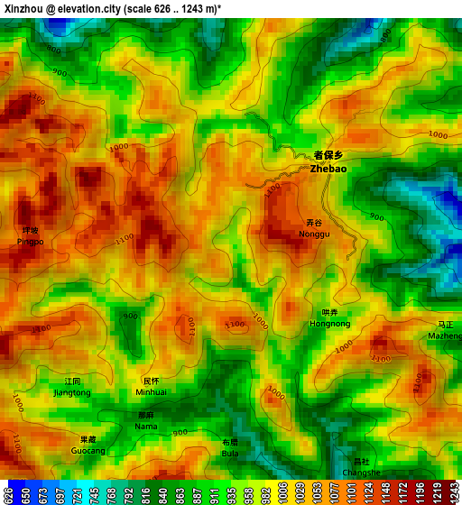
Below is the Elevation map of Xinzhou, which displays elevation range with different colors. Scale of the first map is from 626 to 1243 m (2054 to 4078 ft) with average elevation of 978.5 meters (=3210 ft) [note 1]
These maps also provides idea of topography and contour of this city, they are displayed at different zoom levels. More info about maps, scale and edge coordinates you can find below images.
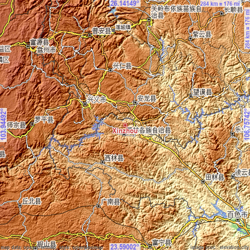
| \ | Map #1 | Topo.Map |
| Scale [m] | 626..1243 m | × |
| Scale [ft] | 2054..4078 ft | × |
| Average | 978.5 m = 3210 ft | × |
| Width | 8.87 km = 5.5 mi | 283.7 km = 176.3 mi |
| Height | 8.87 km = 5.5 mi | 283.7 km = 176.3 mi |
| ↑Max Latitude | 24.912203° | 26.14149° |
| Latitude at center | 24.87234° | 24.87234° |
| ↓Min Latitude | 24.832464° | 23.59002° |
| ← Min Longitude | 105.307225° | 103.94492° |
| Longitude center | 105.35117° | 105.35117° |
| →Max Longitude | 105.395115° | 106.75742° |
Nearby cities:
Cities around Xinzhou sort by population:
• Anshun elevation 1374 m
163.9 km,  20°
20°
• Napo Chengxiangzhen 1017 m
161.2 km,  163°
163°
• Jinping 1463 m
147.3 km,  230°
230°
• Zhong’an 1882 m
142.9 km,  308°
308°
• Xinhua 975 m
140.1 km,  167°
167°
• Danfeng 1837 m
135.6 km,  268°
268°
• Sicheng 1047 m
134.8 km,  112°
112°
• Tongle 1169 m
123.6 km,  91°
91°
• Leli 583 m
107.1 km,  122°
122°
• Luoxiong 1520 m
106.8 km, 270°
• Liancheng 1245 m
95.4 km,  197°
197°
• Bada 1297 m
40.5 km,  219°
219°
Multilingual:
 En español:
Xinzhou elevación 961 m.
 En France:
Xinzhou élévation 961 m.


Sources and notes:
- [note 1] Map square and city borders are not equal. Map elevation data is calculated only from area inside that square.
- [src 1] Elevation data from geonames database provided with same terms of usage.
- [src 2] The elevation map of Xinzhou is generated using elevation data from NASA's 3 arcsec (90m) resolution SRTM data.
- [src 3] Base (background) map © OpenStreetMap contributors tiles are generated by Geofabrik and OpenTopoMap.
Copyright & License:
This Xinzhou Elevation Map is licensed under CC BY-SA. You may reuse any part from this page, if you give a proper credit by linking to this URL:
 More info on terms of use page.