Anshun elevation
Anshun (Guizhou), China elevation is 1374 meters and Anshun elevation in feet is 4508 ft above sea level [src 1]. Anshun is a populated place (feature code) with elevation that is 816 meters (2677 ft) bigger than average city elevation in China.
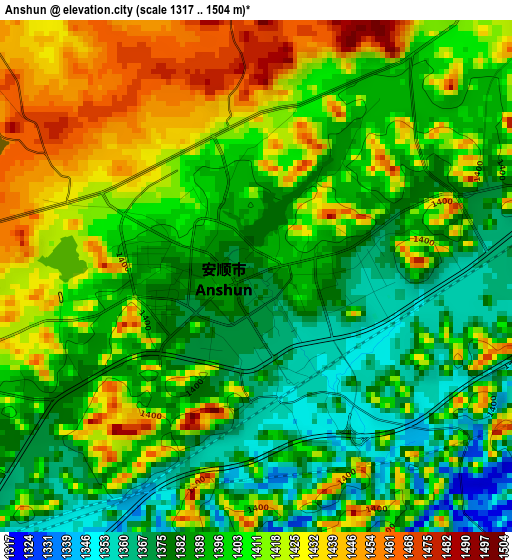
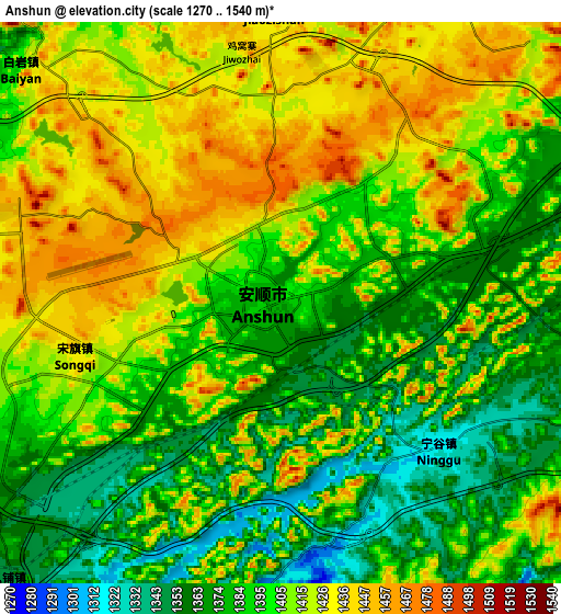
Below is the Elevation map of Anshun, which displays elevation range with different colors. Scale of the first map is from 1317 to 1504 m (4321 to 4934 ft) with average elevation of 1402.1 meters (=4600 ft) [note 1]
These maps also provides idea of topography and contour of this city, they are displayed at different zoom levels. More info about maps, scale and edge coordinates you can find below images.
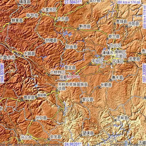
| \ | Map #1 | Map #2 | Topo.Map |
| Scale [m] | 1317..1504 m | 1270..1540 m | × |
| Scale [ft] | 4321..4934 ft | 4167..5052 ft | × |
| Average | 1402.1 m = 4600 ft | 1402.7 m = 4602 ft | × |
| Width | 8.76 km = 5.4 mi | 17.53 km = 10.9 mi | 280.5 km = 174.3 mi |
| Height | 8.76 km = 5.4 mi | 17.53 km = 10.9 mi | 280.5 km = 174.3 mi |
| ↑Max Latitude | 26.289407° | 26.3288° | 27.50431° |
| Latitude at center | 26.25° | 26.25° | 26.25° |
| ↓Min Latitude | 26.21058° | 26.171147° | 24.98201° |
| ← Min Longitude | 105.889385° | 105.845439° | 104.52708° |
| Longitude center | 105.93333° | 105.93333° | 105.93333° |
| →Max Longitude | 105.977275° | 106.021221° | 107.33958° |
Nearby cities:
Cities around Anshun sort by population:
• Guiyang elevation 1087 m
86.4 km,  64°
64°
• Liupanshui 1799 m
116 km,  289°
289°
• Duyun 815 m
157.9 km,  89°
89°
• Bijie 1471 m
133.4 km,  331°
331°
• Xiaoweizhai 757 m
157.7 km, 92°
• Weining 2169 m
181.8 km, 291°
• Renhuai 848 m
177.5 km,  15°
15°
• Wufeng 1892 m
172.4 km,  320°
320°
• Tongle 1169 m
168.8 km,  157°
157°
• Xinzhou 961 m
163.9 km,  200°
200°
• Hezhang 1531 m
154.4 km,  308°
308°
• Zhijin 1313 m
49.2 km,  340°
340°
Multilingual:
 En español:
Anshun elevación 1374 m.
 En France:
Anshun élévation 1374 m.


Sources and notes:
- [note 1] Map square and city borders are not equal. Map elevation data is calculated only from area inside that square.
- [src 1] Elevation data from geonames database provided with same terms of usage.
- [src 2] The elevation map of Anshun is generated using elevation data from NASA's 3 arcsec (90m) resolution SRTM data.
- [src 3] Base (background) map © OpenStreetMap contributors tiles are generated by Geofabrik and OpenTopoMap.
Copyright & License:
This Anshun Elevation Map is licensed under CC BY-SA. You may reuse any part from this page, if you give a proper credit by linking to this URL:
 More info on terms of use page.