Jinzhong elevation
Jinzhong (Yunnan), China elevation is 2874 meters and Jinzhong elevation in feet is 9429 ft above sea level [src 1]. Jinzhong is a seat of a third-order administrative division (feature code) with elevation that is 2316 meters (7598 ft) bigger than average city elevation in China.
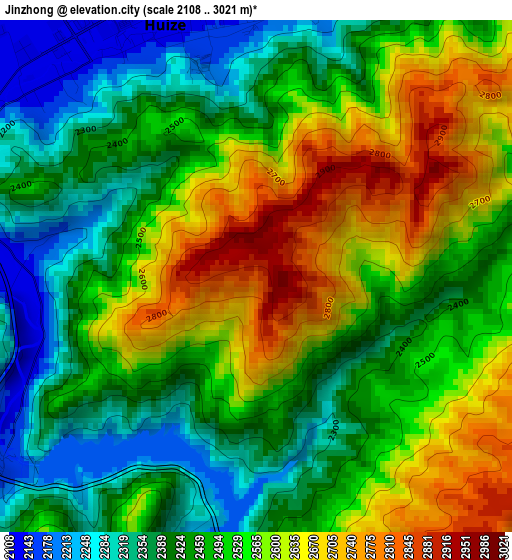
Below is the Elevation map of Jinzhong, which displays elevation range with different colors. Scale of the first map is from 2108 to 3021 m (6916 to 9911 ft) with average elevation of 2502.1 meters (=8209 ft) [note 1]
These maps also provides idea of topography and contour of this city, they are displayed at different zoom levels. More info about maps, scale and edge coordinates you can find below images.
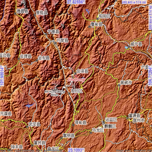
| \ | Map #1 | Topo.Map |
| Scale [m] | 2108..3021 m | × |
| Scale [ft] | 6916..9911 ft | × |
| Average | 2502.1 m = 8209 ft | × |
| Width | 8.76 km = 5.4 mi | 280.1 km = 174 mi |
| Height | 8.76 km = 5.4 mi | 280.2 km = 174.1 mi |
| ↑Max Latitude | 26.415314° | 27.62886° |
| Latitude at center | 26.37595° | 26.37595° |
| ↓Min Latitude | 26.336573° | 25.1093° |
| ← Min Longitude | 103.262445° | 101.90014° |
| Longitude center | 103.30639° | 103.30639° |
| →Max Longitude | 103.350335° | 104.71264° |
Nearby cities:
Cities around Jinzhong sort by population:
• Qujing elevation 1887 m
110.1 km,  154°
154°
• Zhaotong 1974 m
112.2 km,  21°
21°
• Weining 2169 m
106.2 km,  60°
60°
• Songyang 1909 m
120.1 km,  193°
193°
• Tongquan 2034 m
111.6 km,  166°
166°
• Huili Chengguanzhen 1798 m
110.4 km,  286°
286°
• Xiping 1865 m
99.4 km, 150°
• Pisha 1204 m
94.5 km,  324°
324°
• Wenping 2018 m
93.5 km,  13°
13°
• Rende 1865 m
91 km,  181°
181°
• Huidong 1676 m
78.3 km, 291°
• Xinhua 767 m
68 km,  326°
326°
Multilingual:
 En español:
Jinzhong elevación 2874 m.
 En France:
Jinzhong élévation 2874 m.
 Auf Deutsch:
Jinzhong höhe über dem Meeresspiegel ist 2874 m.

Sources and notes:
- [note 1] Map square and city borders are not equal. Map elevation data is calculated only from area inside that square.
- [src 1] Elevation data from geonames database provided with same terms of usage.
- [src 2] The elevation map of Jinzhong is generated using elevation data from NASA's 3 arcsec (90m) resolution SRTM data.
- [src 3] Base (background) map © OpenStreetMap contributors tiles are generated by Geofabrik and OpenTopoMap.
Copyright & License:
This Jinzhong Elevation Map is licensed under CC BY-SA. You may reuse any part from this page, if you give a proper credit by linking to this URL:
 More info on terms of use page.